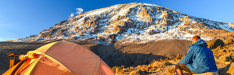
Kilimanjaro
climbing mount kilimanjaro - preparation
kilimanjaro route- fatest, cheapest, best, popular
lemosho route
marangu route
rongai route
northern circuit route
umbwe route
shira route
mount kilimanjaro weather
mount kilimanjaro altitude sickness
mount kilimanjaro costs
mount kilimanjaro location
mount kilimanjaro packing
mount kilimanjaro guides and porters
mount kilimanjaro height
mount kilimanjaro training
mount kilimanjaro best time to visit
mount kilimanjaro facts
CLIMBING MOUNT KILIMANJARO - PREPARATION
A comprehensive preparation guide for a successful summit
Mt. Kilimanjaro is the highest free-standing mountain at 5895m, every year over more than 30000 people climb Kilimanjaro. All preparation needed to climb.
See 20 ways how to prepare for climbing Mount Kilimanjaro based on important.
1). Choose a minimum of 8 days climbing Mt Kilimanjaro.
Why 8 days because you will have a summit success rate of 90% and you will have enough time to acclimatize. So, you will have significantly reduced the risk of mountain sickness.
Choosing less day reduce your summit success rate (40% for 5 days climb). Your chances of success reduce drastically if you select less days on Kilimanjaro. Also, good acclimatization should be your top concern.
2. Choose the right route for you trek
The best route to climb Mount Kilimanjaro can be analyzed based on the many factors. We will analyze the right Kilimanjaro route based on 7 Key factors. All Mount Kilimanjaro climbing routes differ in length, cost, days and scenery.
We can all agree there is no single the best route to climb Mount Kilimanjaro but, in my opinion, Lemosho route is the best as it's the most beautiful and has the highest summit success rate.
Which route is the best to climb Mount Kilimanjaro all details.
3. Planning the date.
Best time to climb Mt. Kilimanjaro are the dry months Jan/Feb and Aug/Sep. but also June and October are good. weather HYPERLINK "https://www.mountkilimanjaroguide.com/kilimanjaro-weather.html" on Kili HYPERLINK "https://www.mountkilimanjaroguide.com/kilimanjaro-weather.html"m HYPERLINK "https://www.mountkilimanjaroguide.com/kilimanjaro-weather.html"anjaro
Mt. Kilimanjaro Weather
The Mt Kilimanjaro weather (good or bad) affects your climb and your success rate chances. When to plan your climb for Kilimanjaro is an important decision.
Bad weather on Mount Kilimanjaro not only makes for a miserable(bad) trek and ruins your pictures, most importantly it simply makes the climb very hard!
Your chance to reach the summit increases if the weather on Kilimanjaro is good.
Mount Kilimanjaro close to equator. There are only dry and rainy periods seasons.
Climbing Mount Kilimanjaro during the rainy season means you have to go through very deep mud on the first days.
At higher altitude fog and drizzle. Slowly the moisture will creep into your clothes and gear.
On top you have to fight through ice and snow. Having moisture in your clothes, is not going to help with the cold on top of Mount Kilimanjaro.
But there are other factors to consider as well. The temperature, the view and the number of people trekking the mountain.
There is no accurate and fast answer on single best time to climb Kilimanjaro.
See Kilimanjaro weather details every month.
The Weather on Kilimanjaro - When is the best time to Climb?
January - March
Mid-January - mid March is a good time to climb Mount Kilimanjaro. The weather is average, not so cold, not so wet, and there aren't as many trekkers. It’s mainly dry, clear with few clouds and occasional small showers. Thou in March the chances of rain increase as you approach the rain season.
April - June
The long rainy season starts the end of March to mid-June. It's impossible to predict exactly when it stops raining. These months are so wet that many operators simply do not offer Kili climbs in April/May at all.
June - August
The rain gradually stops, and the temperatures drop on Kilimanjaro. The weather on Kilimanjaro is not very dry and clear but the nights will be very cold. The number of climbers increases as the months progresses.
August - October
August and the September is the peak climbing season on mt Kilimanjaro. The weather is perfect with clear days and warmer than in June and July.
You may however see clouds blanketing the rain forest, moorland zone and the southern routes you may get rained on the first and second days. But once you leave the rain forest behind then all will be good. These good conditions last to mid-October when the short rains start.
October -November
The weather on mt Kilimanjaro becomes unstable and the number of people climbing drops. There will be clouds and occasional thunderstorms. You should be equipped to withstand the occasional shower. This can present any major problems.
November -December
November there is small rains to, and the rain goes on to mid-December. The temperatures will drop, and the rains may sometime continue for 2 to 3 days. This is Not the best time to climb Kilimanjaro.
December-January
The 4 to 6 weeks around Christmas and New Year are the second peak climbing season on climbing Kilimanjaro. Traffic is very high despite there still being a small chance of rainfall and thick clouds at the lower regions. This is not the time I would choose.
Important to note about the weather on Mt Kilimanjaro.
You may decide to climb any time, be it because you may want to avoid the population or because that is the only time off from work. In that case take the Rongai Route. It is much drier than the other Mount Kilimanjaro HYPERLINK "https://www.mountkilimanjaroguide.com/kilimanjaro-routes.html" routes.
And if you want the best weather on Kilimanjaro but less people, choose the Rongai, Shira and Lemosho than on the overcrowded Machame route and Marangu route.
The other thing are the temperatures.
The day and night temperatures are very different. In that respect the temperature during the day can be well above 30°C and the night below 0°C. At the summit temperature at night can drop to -20°C (-5F).
4). Good physical conditioning is important.
You should not aim at running; you are hiking up and down. Endurance training and leg strength is Key. No problem if you are mixing up, you're training with running but it should not be your focus.
You should put on weighted backpack to build up the weight you will carry. Train 4 to 5 times a week. We will talk you through the best way to prepare for Mount Kilimanjaro climb.
5). Understand elevation gains.
Think about this a bit more. You will daily walk distances and elevation gains during Kilimanjaro climb. So, you should be able to build a training timetable that works for you.
Thou at Kilimanjaro you will have 30% to 50% less oxygen the best way to prepare for is by putting your leg muscles under more pressure at sea level.
The best way to achieve this is by adding weight to your backpack at the gym on very training session. You should increase the weight weekly.
6). Build the right training program.
So, this is just an addition to number 3. Your preparation should start 1 to 3 months before of your Kilimanjaro climb. If you can’t access hills and mountains, you can train by walking at least 1 hour a day.
Why not get professional advice from our experts. They have climbed Kilimanjaro many times.
7). The right clothing for Mount Kilimanjaro.
It is said that the temperatures at Mount Kilimanjaro can be above 100 degrees to below zero. It is important for all climbers to understand how to dress according to mountain weather.
Wearing many layers of cloth is the best way to keep your body in good temperature range no matter what the at the mountain is.
Layering is versatile, thermally and space efficient. A climber can add or remove cloths to adapt with change in weather, activity and body temperature.
Scientifically, it is warmer to wear many thin layers than one thick single layer because the air between the layers provides insulation and takes small space in your backpack.
The technical clothing you bring on Mount Kilimanjaro can be categorized into three types of layers: mid layer, base layer and outer shell. Each layer performs a specific function.
Base Layer
It is moisture-wicking item that is worn against the skin. Moving sweat from your body, this layer should keep you dry and provide some insulation.
Base layers can be worn alone in warm weather or doubled-up during cold weather. Try wearing them on and see if you like the feeling of them against your skin because you will spend the entire week on Mount Kilimanjaro with base layers on.
Mid Layer
The purpose of a mid-layer is to provide warmth. Therefore, you should look for cloth that have good insulating qualities like Wool or cotton.
Fleece provides good insulation as they are thin, comfortable, fast-drying and lightweight but lacks wind protection.
Note that a heavyweight down jacket is used as an outer layer. Can be worn over a thin mid layer, such as fleece, or over an outer layer, such as a hard shell.
Synthetic insulated jackets are not as warm or light as down, but they function even when wet.
Outer Layer
They are designed to provide protection against wind, rain and snow.
Outer layers have built in insulation, but we recommend having each layer for greater versatility.
With this gear you will be able to withstand whatever weather at Mount Kilimanjaro It is very important that you note changing conditions when hiking and adapt (unzip layers before you sweat, zip up or add layers before its cold, wear waterproof gear before you get wet).
8). Get trekking boots for Mount Kilimanjaro climb.
It is very important to buy good trekking boots early. I prefer (La Sportiva Trango GTX trekking boots). Trekking boots should have rigid sole on. The Trango boots are waterproof, lightweight warm and very solid.
The sole of the climbing boots should not the slippery. Make sure your boots are in a good condition.
9). Vaccination needed for Mount Kilimanjaro.
You will need to some vaccinations which are mandatory before coming to Tanzania. Also be protected against malaria. Your doctor will recommend medication that you will need to bring.
We include all vaccinations and medications required for Mount Kilimanjaro Check out our list.
10). Hydration on your Kilimanjaro climb is important.
You need to drink a lot of water prior and during the climb. Drink 4 to 5 liters per day on the mountain. Make sure you are well hydrated.
Avoid dehydrating at altitude without noticing. Our bodies adjust to the high altitude by eliminating more water. Keep drinking more water every time at Kilimanjaro.
11). Getting the pace correct can make all the difference climbing Kilimanjaro.
We have enough experience to help you summit of Kilimanjaro. Nevertheless, doesn’t mean you should not prepare. You need have to trained and prepare for Kilimanjaro climb.
On Kilimanjaro with 30 to 40% less oxygen and less than 50% oxygen getting to your muscles above 18,000 feet. So, the pace you move at and heart rate you maintain on the mountain is so important.
Let all the anyone people pass you by. You are trying to get from point A to point B using little energy as possible. You need to keep low heart rate as possible.
To minimize the damage on your muscles on a daily basis. Acclimatize slowly and to give yourself the best chance of summit Kilimanjaro.
12). Pick a team who pay their staff correctly.
You make sure your choice a trekking operator who pays well their guides, cook and porters. Most of the operators do not pay well their staff below the standard required by Kilimanjaro national park.
Poor payment of porters results in many deaths during Mount Kilimanjaro climb, because they cannot afford good clothes, and equipment needed for the climb.
13). Have oxygen on your Kilimanjaro climb.
You need to have oxygen each day high on Kilimanjaro. We have one bottle of oxygen for 5 people. We carry this every day of the Kilimanjaro climb.
Always a number of other teams and people are looking to use our oxygen! You need bottled oxygen on your Kilimanjaro climb.
You also need daily monitoring for heart rate and oxygen levels. To minimize the risk, you face during Kilimanjaro climb. It is really important from the beginning of the trip.
14). Have emergency evacuation access.
The Lemosho route offer the best emergency evacuation road on Kilimanjaro. This evacuation road is situated between Shira camp 11,482 feet and Shira camp 2 at 12,631 feet.
Our treks have Flying Doctor coverage option and we can get you off the mountain very quickly as possible on the western side of Kilimanjaro.
On day 3 we get up to 13,123 feet. We will monitor your oxygen saturation daily but if you are not coping with the lack of oxygen, we will see real indicators at this elevation and if you need to descend from the mountain.
We will take you to a hospital very quickly from here. This is a very important safety factor you need to consider before Kilimanjaro climb.
15). Make sure you have proper support on your summit climb.
We always help other teams on Kilimanjaro they have less guides for their people and when people get in trouble we have to help where possible most lack medical equipment’s.
We will have 1 guide and 1 support staff heading to the summit for each climber heading to the summit it is necessary.
In case you are struggling to get down the mountain you need to have this safety measure in place and minimize the risk you are taking on Kilimanjaro climb.
16). Join a small group.
Small group gives better attention, and concerns on the mountain can be managed faster. In a smaller team you have better access to staff and our guides can get to know you better and spot altitude related issues faster.
Our guides will be able to spot small changes in your behavior and react quickly. Smaller groups are more relaxed, safer and more enjoyable experience on Kilimanjaro climb.
We have a maximum of 12 people makes a more successful, enjoyable and positive overall experience for each team member.
17). Getting Into Shape
Training for Kilimanjaro and on Kilimanjaro is the key to a successful Mount Kilimanjaro summit.
Preparation should start 1 to 3 months before your Kilimanjaro climb. If you can’t access hills and mountains, you can train by walking at least 1 hour a day.
You should not aim at running, up and down at Kilimanjaro.
Endurance training and leg strength are very important. No problem if you mix up, you're training with running but it should not be your focus.
In most cases of the failed summit, it’s because of altitude sickness.
18). Practice the right breathing techniques needed for high altitude trekking.
The right technique is to deep breaths through your nose and out through your mouth. No need to be doing this every day and it will vary from start to summit night.
This technique needs focus and trust me you will need this technique during your summit night to make sure you are giving your brain, lungs, heart and body enough oxygen to reach the uhuru peak summit and get back safely below 18,000 feet.
19). Mount Kilimanjaro Packing List Tips
Mount Kilimanjaro packing list that you can use during the actual packing of your bags is included in the Kilimanjaro climbing guide click the link to learn more.
Which Kilimanjaro gear is essential and why is it explained in the Kilimanjaro equipment list.
There are more things you may want to pack for Kilimanjaro, beyond that essential equipment.
Below are tips and ideas for packing before Kilimanjaro.
List of Packing Tips for the Flight and for Mount Kilimanjaro
⦁ Pack all essential gear in your hand luggage because it's the only way to be sure it arrives on time. African airports are always losing luggage.
⦁ Wear your boots on during the flight! Your boots are a very important item that you can NOT afford to lose. You should not wear in another pair of boots in a few days recommended.
⦁ Any gear that is valuable to lose should stay home.
⦁ Flying from or via the US you are not allowed to lock bags. Pack intelligently. Valuables should go on the bottom of the bag. On top, you can place underwear, socks, and maps.
⦁ Theft is not really a problem unless you are quite irresponsible. Usually, it is opportunistic because most people in Africa are very poor.
⦁ Pack sunscreen and mosquito repellent you need and some extra. It's not easy to find in Tanzania.
Rechargeable batteries are good, but you may not be able to recharge them while in Mount Kilimanjaro. Get batteries for back up. Batteries are available everywhere.
List Of Packing Tips for Mount Kilimanjaro
⦁ Pack everything you really need but nothing else. You are only allowed to take 15 kg up the mountain anyway or you may have to pay for an additional porter. Example toothbrush and toothpaste, soap and a mini towel.
Anything You Don't Need to Leave While Climbing Kilimanjaro
⦁ Take clothes pegs or strong clips you can attach items outside your pack during the day, to dry in the sun in the afternoon.
⦁ Socks, you can wash them at night and dry them on your pack during the day.
⦁ Water bottles you should get at least one bottle that can double as a hot water bottle.
⦁ You should be able to wear all your clothes on top of each other.
⦁ Don't carry water on the outside during the summit night because it will freeze.
⦁ During the summit, climb carry your camera and battery on your body to keep them warm.
⦁ Take enough money for tipping your guides, cook, and porters, but leave all valuables in the hotel safe with a written receipt.
20). Get A Visa
You should have a visa to visit Tanzania and passport valid for 6 months.
The easiest way is upon arrival in Tanzania at the airport. It's cost 50 USD except for USA citizens it cost 100 Usd to get a visa.
KILIMANJARO ROUTE- FATEST, CHEAPEST, BEST, POPULAR
Finding your path to summit success
Mt. Kilimanjaro has seven routes. Marangu, Machame, Lemosho, Shira, Rongai, Northern Circuit and Umbwe. Prons and Cons of each route and why choose it
There are many routes leading to the summit of Mount Kilimanjaro in Tanzania. Each route has its own pros and cons considering the beauty of the terrain and scenery, costs, duration spent, popularity, difficulties, acclimatisation profile and success rates. mild
Clarifying your priorities early makes the decision become relatively easy. Deciding on a route up Kilimanjaro is definitely a personal choice and should be done so with care.
MACHAME ROUTE A.K.A WHISKEY ROUTE
This the most popular route today because of its high success rates Machame is considered the best Kilimanjaro route and because of its popularity, high success rates and the beauty of highlights on the trails.
Machame offers good acclimatisation, high success rates, beautiful scenery, varying landscapes and a variety of terrain however can get crowded at times. Although machame is not technically much more difficult, it is considered to be a bit more challenging. It takes a minimum of six or seven days to summit with machame route.
The route is approximately 62km(37miles) to the peak.it is referred to as the Whiskey route, given its reputation for being a troublesome climb, in contrast to the better Marangu route “Coca Cola route”. The success rate of the 7-day version of the Machame Route is around 85%. The 6-day one, has a success rate of about 75%. If you take a day longer (7days), your chances increase significantly.
Some months/seasons are more suitable than others to climb Kilimanjaro though the trekking and climbing can be done all year round. Dry season includes January, February, march and June to October while rainy season lasts from April to May and November to December.
The route is best enjoyed during the dry season which is the busiest (high) season of the year. The wet (low) season is the quiet time to climb Kilimanjaro since there is low traffic.
The Barranco wall is one of the key attractions in routes though Old Shira route, Lemosho route and umbwe share this feature. At 257m the wall is seen as one of the difficult and hardest part of the route but attainable and enjoyable since it is done with both legs and hands to climb it.
Why Choose Machame Route? TIPS/Characteristics/Facts/Pros
- Runs approximately 62kms/37miles gate to gate.
- Most Popular and profiled because it’s the oldest route.
- Offers a great opportunity for acclimatization (6-7 days hike)
- Scenery is varied and passes 5 Climatic Zones (i.e., cultivation zone, Rainforest Zone, Heath zone & Mooreland zone, Alpine desert zone and the Arctic zone)
- Overall, Success rate is around 80%
- It’s a camping route (i.e., no Huts like the Marangu route)
Cons of Machame Route
- High Traffic/ Crowding
- Steep hard trek
Machame 7/6 Day Route Itinerary
To reduce the itinerary to six (6) days, you skip the night in the Karanga Valley and as an alternative, a trek from the Barranco camp to the Barafu camp in one day.
Day 1: Machame Gate (1830m/6000ft) - Machame camp (3030m/9940ft)
Walking distance: 5.5 km/3.5 miles
Walking time: 6-7 hours
Vegetation Type: Montane Forest
After breakfast a short drive from your hotel to the gate takes about 45-50mins. Whichever way you reach the gate, the guides, porters and yourself need to complete the registration formalities before the ascent. The destination here is the machame camps which takes about 6-7 hours to hike. In no time you will be hiking through the rainforest.
The forest is beautiful, a real fairy-tale forest, rich in primeval ferns and endemic flowers e.g. impatient Kilimanjaro lush and deep green, albeit misty. (That's why it's also named "cloud forest". It's permanently in the clouds.) The black and white colobus monkeys might also be spotted at the canopies of the forest grasping through leaves. Ferns, lichens and moss are present along the way.
Day 2: Machame Camp (3030m/9940ft) - Shira 2 Camp (3850m/12630ft)
Walking distance: 5.5 km/3.5 miles
Walking time: 5-6 hours
Vegetation Type: Heath and Moorland
Early breakfast and take off immediately for a long walk that will see you reach Shira around mid after noon. Here the landscape changes from lush green rainforest to dry moor and heathland. The beautiful range of the mountain can be viewed upon arrival at the campsite if the sky is clear. The Kibo glaciers glow to the setting sun while enjoying an evening meal before sleeping in your tent.
Day 3: shira 2 Camp (3850m/12630ft) - via Lava Tower (4640m/15220ft) - Barranco camp (3985m/13070ft)
Walking distance: 10 km/6.2 miles
Walking time: 6-7 hours
Vegetation Type: Semi desert
This day involves a climb of approximately 700m from the new Shira camp (3850m) upwards the Lava Tower (4640m) a 300 ft volcanic plug. You will notice a decrease in oxygen level while ascending over 4500m.Though not very steep the climb is often more strenuous and exposes the rocky ground of the lava ridges since the heather vegetation fades.
At the Lava Tower you will have lunch before a 6-7-hour trek of descending into the beautiful Barranco Valley (which was formed as a result of a mass landslide over 100,000 years ago) to the Barranco camp where you will have dinner. The Barranco valley is shielded by towering cliffs and has a greener vegetation. The giant senecio and lobelias are present in this altitude since its an alpine desert.
The Barranco Camp is without a doubt the most spectacular campsite on the route, with fantastic views of Kibo, the Western Breach and the first of the southern glaciers, a fitting reward after a strenuous day. This is an important day for acclimatisation; hence altitude sickness might be experienced for a short while.
You have been quite high today, but by climbing high and sleeping low you are giving your body the best chances to adapt. Don't be disheartened about the loss of hard-earned altitude. Climbers will reach the Barranco Camp via Machame, Shira, Lemosho, or even on a special route around the northern circuit, from this point onwards all climbers follow the same trail.
Day 4: Barranco camp (3985m/13070ft) - Karanga Camp (4040m/13255ft)
Walking distance: 5.5 km/3.5 miles
Walking time: 4-5 hours
Vegetation Type: Alpine Desert
On this day the Barranco wall stands before you to conquer. There are tales about the Barranco Wall "need of climbing experience" but it’s at only a few points where you need to scramble which does not require expertise.
To conquer the wall some stages will require use of hands for a better grip and your guide will be with you every step of the way in case you need a hand. It is energetic to climb because the air is so thin and it is very steep with its numerous ascents and descents allowing further acclimatisation before reaching the mountain ridge.
The wall takes about an hour and a half to scale, and as you come over the final ridge you are met with a breathtaking view of Kibo, which all of a sudden looks a lot closer! Don't forget to turn around every now and then and appreciate the views, including the line of climbers behind you.
Another trek between 4-5 hours will see you reach Karanga Camp a cloudy green oasis. Along the ridge notice landscapes with its stunning desert and vegetations. From there it’s enough time to rest and play fun games e.g. cards before the evening meal.
Day 5: Karanga Camp (4040m/13255ft) - Barafu camp (4680m/15360ft)
Walking distance: 3.5 km/ 2.2 miles
Walking time: 4-5 hours
Vegetation Type: Alpine Desert
The walk on this day is short. You leave the Karanga Valley on an easy but steep trail, through an increasingly hostile landscape, with the Southern Glaciers coming up to your left. The path is steeper and takes 4-5 to the Barafu Camp for lunch. Barafu Camp has an otherworldly feeling on the edge of an exposed ridge in a bleak and barren landscape.
The advantage of having the additional night at Karanga in your schedule is having a lot of time to eat, rest and recover, prepare everything for the summit attempt, maybe even go on a short acclimatisation and familiarize yourself with the area before the sunset then have an early night.
Most of the day will be spent walking through desert terrain, with a view of Kibo on your left. Stepping out of control in the dark is quite common while trying to find the toilet.
Day 6: Barafu Camp (4,680m) – Uhuru Peak (5,895m) – Mweka Camp (3,080m)
Walking distance: 5 km/3 miles
Walking time: 6-7 hrs to crater rim + 1-2 hours up to Uhuru
Vegetation Type: Arctic/Glaciers
This is a day to remember in your lifetime. On this earliest start of the day your guides will always wake you up sometime between 11 pm and 1 am. There will be some hot drinks and early snacks. You should pack some rain gears, enough water, gloves, camera and the right clothes. Make sure everything you are draining is bone dry! Don’t forget fresh batteries for your head torch since in absence of the moon it will be your only source of light on your ascent to Stella Point to reach the crater rim.
After an initial little scramble on a steeper, cruel and hard cliffs to get out of the Barafu Camp, the pathway becomes easier to follow. It takes many people 6-7 hours to reach Stella Point from the camp. If you are among the slower climbers, don't worry.
The people who don’t feel the effects of the altitude are few. Hopefully, the worst you have to deal with is a headache and the occasional wave of nausea. Vomiting is quite common here and is no reason for concern. Long breaks in these temperatures are discouraged since the cold starts creeping into your hands and feet first, then into the body. You have no choice but to grab your gear and keep going, the earlier the better. Don’t push yourself too hard, you may feel terrible.
Don’t be pressured into moving faster than you feel comfortable to but keep moving. Stable, steady, one tiny little step after the other and before you know you will be up there, admiring the rising sun from 5752 meters. Even though most say the climb up to Stella Point is the hardest part, an approximately 30 minutes’ walk around the crater rim and the glaciers to Uhuru peak can prove challenging too.
The more time you spend at this high altitude, the more you are going to feel it. The path rises steadily. It may not look steep, but by now every step uphill to the peak can be a battle but staying positive will get you there. It takes 1-2 hours from Stella point to Uhuru peak.
At the peak (Uhuru) there is no way to define/imagine the experience of climbing to nearly 6000m altitude. Some people get emotional, some are high and dazed, they barely take any notice at all. This is a time for many hugs and photos but for a few minutes since it is too dangerous and cold and probably be running out energy.
From there it’s downhill back to Stella point then to Barafu for lunch. The descendants will need the walking poles because it’s hard on the knees as you go downward plus the trail is full of pebbles and gravel. At some point its actually quite fun to run on gravel. After lunch you descend for three more hours to Mweka camps or millennium camps where you just want to relax or sleep and spend your last day on the mountain.
Later that night dinner is often a much sparkling affair, with everybody's eyes shining as they recount the experiences of the day. With no doubt you will sleep well that night!
Day 7: Mweka Camp (3,080m) – Mweka Gate (1,650m)
Walking distance: 9.1 km/6 miles
Walking time: 4-5 hours
Vegetation Type: Rainforest
It's your last day on the mountain and you may get excited about it. After a scrumptious breakfast and a local traditional farewell from team, you start a final descent. The path is rather steep and that the steps on the steepest sections are hell for your abused knees.
Trekking downhill through the beautiful rain forest is an opportunity to spot abundant bird life, rodents, endemic plants and cheeky colobus monkeys along the trail.
Upon Mweka gate arrival, you will check out and bid cheerio to your guides then transferred to your hotel for hot showers, cold beers and a good time. All you will do is reflect and reminisce on how you conquered the Roof of Africa.
LEMOSHO ROUTE
Your complete guide to Lemosho route of Mt Kilimanjaro
This is one of the best overall routes, with an excellent chance of reaching the summit often completed in seven days.
LEMOSHO ROUTE
This route was established as alternative to Shira route to reduce an increasing number of hikers. It is arguably considered the most scenic Kilimanjaro route after the northern circuit route granting panoramic views on most sides of the mountain. Furthermore, the route has low traffic (due extra transport and extra day payments), high summit success rate, remoteness and a beautiful scenery with greater chances of seeing wildlife mostly herbivores.
If you are physically fit and with hiking experience, this is definitely a route for you since it is a narrow wilderness trail right from the start and runs approximately 70km/42miles. Only the first two or three days of the two routes are different but later joins the machame route at the lava tower. Despite being slightly expensive, it has around a success rate of 92% and greater chance of acclimatisation since it is done over a long period of time (7 or 8 days).
Why choose Lemosho Route? Tips/Characteristics/Facts/Pros
- Best Quiet trail with low traffic especially during the peak season
- Most scenic with wildlife herbivores like elephants, buffaloes etc.
- Camping accommodation
- Expensive due to remoteness and additional transport costs
Cons of Lemosho Route
- Inaccessible in the wet/rainy season
- Expensive
LEMOSHO ROUTE ITINERARY
DAY 1: Londorossi gate (2100m/6900ft) – Big Tree/Mti Mkubwa camp (2700m/8700 ft)
Walking Distance: 6km/3.7miles
Walking Time:3-4 hours
Vegetation Type: Rainforest
The journey starts at the scenic Londorossi Gate located at the south side of the mountain 6,900ft to Mti Mkubwa at 8,695ft. The climb is smooth, gradual and with a high success rate. The trail goes past villages, coffee firms, and a lush fairy like dense rainforest. There are better chances of coming across some primates like troops of colobus monkeys, blue monkeys, mammal species elephants and water buffaloes.
In about two to three hours you arrive at the pretty Mti Mkubwa camp located under a big tree with plenty of monkeys and birds most active and likely to spot during evenings and mornings. At the camp, the experienced and skilled mountain crew will pinch tents and prepare dinner.
Day 2: Big Tree Camp (2650m/8695 ft) – Shira 1 (3480 m/11420 ft)
Walking distance: 8 km/5 miles
Walking time: 4-5 hours
Vegetation Type: Meadows
The day starts with an early breakfast, then a trek upwards to 3500m which will allow you to start the acclimatization process gradually. The trail is very sheer but sometimes after lunch it flattens out giving spectacular views of Kibo volcano and the Shira plateau. There are more steep ridges and at times you might feel exhausted so do not hesitate to take breaks.
Upon entering the moorland, you will be standing at the edge of the Shira plateau 3612m/11840ft, Shira ridge on the right while Kibo lies ahead of you overlooking the plateau below.
It's all plain sailing from there as you are headed to Shira 1 (3480m/11420 ft) which is one of the highest plateaus on earth. Here you will rest for the day but other fast hikers may opt to proceed to Shira 2.
Day 3: Shira 1 (3480m/11420 ft) – Shira Camp 2 (3850 m/12630 ft) via Shira Cathedral
Walking distance: 11 km/6.8 miles
Walking time: 4 - 5 hours
Vegetation Type: Moorland
This is an acclimatization day to trek across the Shira plateau. The hike will be for a short while gaining an elevation of over 1000 ft. The walk leads gradually uphill, a much more attractive path to the southern edge of the rim and the Shira Cathedral which stands at (3720m/12200ft). The trail is very scenic with boundless views on both sides. After a few hours (4-5) you will reach you will reach the Shira camps. If the weather permits, Shira 2 camp is the best place on the trip to see Mount Meru (the fifth highest summit of Africa). Hikers may opt to take a detour halfway between the route junction and the Shira camp and spend their nights at Fischer campsite (3885m/12745ft) which is often the quietest camp on the mountain or at the Moir Huts (4200m) depending on the tour operators’ package.
Day 4: Shira Camp 2 (3850m/12630 ft.)-Lava Tower (4640 m/15220 ft.) -Barranco Camp (3985m/13070ft)
Walking distance: 9 km/5.6 miles
Walking time: 6-8 hours
Vegetation Type: Semi desert
On this day we leave the heather and moorland behind and enter the alpine desert vegetation. There are spectacular views all around as you continue ascending. The main trail is filled with bends, and you will notice upward and downward movements as you proceed trekking. Later on reaching an intersection, Mountaineers may opt to either head towards the Lava Tower (4,640m/15220) as a detour or for another additional extra night or proceed straight on towards the Barranco camp (3985m/13070ft).
The Lava Tower trail is gentle and you will notice the short heather disappearing as you hike towards it revealing a rock-strewn ground of the lava ridges.
Your body might start experiencing a lack of oxygen (AMS) as you ascend over 4500m but don’t be startled as it happens for a short period of time.
After the Lava Tower, you begin descending downward the gorgeous Barranco Valley which was formed as the result of massive landslides over 100,000 years ago and is much greener with gigantic cliffs. Plants likely to be spotted here are giant senecios and lobelias.
Day 5: Barranco Camp (3985m/13070 ft) – Karanga Camp (4040m/13255 ft)
Walking distance: 5.5 km/3.5 miles
Walking time: 4-5 hours
Vegetation Type: Alpine Desert
On this day the Barranco wall stands before you to conquer. There are tales about the Barranco Wall "need of climbing experience", being "almost impossible" or "perilously dangerous". That's not true at all. Only at a few points do you need to scramble which does not require expertise.
To conquer the wall some stages will require use of hands for a better grip and your guide will be with you every step of the way in case you need a hand. It is energetic to climb because the air is so thin, and it is very steep with its numerous ascents and descents allowing further acclimatisation before reaching the mountain ridge.
The wall takes about an hour and a half to scale, and as you come over the final ridge you are met with a breath-taking view of Kibo, which all of a sudden looks a lot closer! Don't forget to turn around every now and then and appreciate the views, including the line of climbers behind you.
Another trek between 4-5 hours will see you reach Karanga Camp a cloudy green oasis. Along the ridge notice landscapes with its stunning desert and vegetations. From there it’s enough time to rest and play fun games e.g. cards before the evening meal.
Day 6: Karanga Camp (4040m/13255ft) – Barafu Camp (4680 m/15360 ft)
Walking distance: 3.5 km/ 2.2 miles
Walking time: 4-5 hours
Vegetation Type: Alpine Desert
The walk on this day is short. You leave the Karanga Valley on an easy but steep trail, through an increasingly hostile landscape, with the Southern Glaciers coming up to your left. The path is steeper and takes 4-5 to the Barafu Camp for lunch. Barafu Camp has an otherworldly feeling on the edge of an exposed ridge in a bleak and barren landscape.
The advantage of having the additional night at Karanga in your schedule is having a lot of time to eat, rest and recover, prepare everything for the summit attempt, maybe even go on a short acclimatisation and familiarise yourself with the area before the sunset then have an early night.
Most of the day will be spent walking through desert terrain, with a view of Kibo on your left. Stepping out of control in the dark is quite common while trying to find the toilet.
Day 7: Barafu Camp (4,680m) – Uhuru Peak (5,895m) – Mweka Camp (3,080m)
Walking distance: 5 km/3 miles
Walking time: 6-7 hrs to crater rim + 1-2 hours up to uhuru
Vegetation Type: Arctic/Glaciers
A day to remember in your lifetime. On this earliest start of the day your guides will always wake you up sometime between 11 pm and 1 am. There will be some hot drinks and early snacks. You should pack some rain gears, enough water, gloves, camera and the right clothes. Make sure everything you are draining is bone dry! Don’t forget fresh batteries for your head torch since in absence of the moon it will be your only source of light on your ascent to Stella Point to reach the crater rim.
After an initial little scramble on a steeper, cruel and hard cliffs to get out of the Barafu Camp, the pathway becomes easier to follow. It takes many people 6-7 hours to reach Stella Point from the camp. If you are among the slower climbers, don't worry.
The people who don’t feel the effects of the altitude are few. Hopefully, the worst you have to deal with is a headache and the occasional wave of nausea. Vomiting is quite common here and is no reason for concern. Long breaks in these temperatures are discouraged since the cold starts creeping into your hands and feet first, then into the body. You have no choice but to grab your gear and keep going, the earlier the better. Don’t push yourself too hard, you may feel terrible. Don’t be pressured into moving faster than you feel comfortable to but keep moving. Stable, steady, one tiny little step after the other and before you know you will be up there, admiring the rising sun from 5752 meters. Even though most say the climb up to Stella Point is the hardest part, an approximately 30 minutes’ walk around the crater rim and the glaciers to uhuru peak can prove challenging too.
The more time you spend at this high altitude, the more you are going to feel it. The path rises steadily. It may not look steep, but by now every step uphill to the peak can be a battle but staying positive will get you there. It takes 1-2 hours from Stella point to Uhuru peak.
At the peak (Uhuru) there is no way to define/imagine the experience of climbing to nearly 6000m altitude. Some people get emotional, some are on a big high, dazed, they barely take any notice at all. This is a time for many hugs and photos but for a few minutes since it is too dangerous and cold and probably be running out energy.
From there its downhill back to Stella point then to Barafu for lunch. The descent will need the walking poles because its hard on the knees as you go downward because the trail is full of pebbles and gravel. At some point its actually quite fun to scree run. After lunch you descend for three more hours to Mweka camps or millennium camps where you just want to relax or sleep and spend your last day on the mountain.
Later that night dinner is often a much sparkling affair, with everybody's eyes shining as they recount the experiences of the day. With no doubt you will sleep well that night!
Day 8: Mweka (3,080m) – Mweka Gate (1,650m)
Walking distance: 9.1 km/6 miles
Walking time: 4-5 hours
Vegetation Type: Rainforest
It's your last day on the mountain and you may get excited about it. After a scrumptious breakfast and a local traditional farewell from team, you start a final descent. The path is rather steep and that the steps on the steepest sections are hell for your abused knees.
Trekking downhill through the beautiful rain forest an opportunity to spot abundant bird life, rodents, endemic plants and cheeky colobus monkeys along the trail.
Upon Mweka gate arrival, you will check out and bid cheerio to your guides then transferred to your hotel for hot showers, cold beers and a good time. All you will do is reflect and reminisce on how you conquered the Roof of Africa.
MARANGU ROUTE
A comprehensive guide to the Marangu route
One of the most popular – mainly because it is the only route on the mountain that has hut accommodation for hikers.
MARANGU ROUTE A.K.A COCA COLA ROUTE
This is the oldest and well-established route at the Kilimanjaro as the climb is steady and gradual. The route has a total distance of 73km (45 miles) gate to gate. Most people take on the Marangu Route since it allows them to summit in five/six days, easiest trip to organize, has the widest most relaxed path to work on, but that does NOT make it easier to reach the summit rather the short time frame of the route makes altitude acclimatization fairly difficult. Unlike Machame Route or Lemosho, the Marangu Route has a low success rate of around 67%. Only about a third of all climbers make it to Uhuru Peak.
Why then is it called the Tourist Route or the Coca Cola Route?
Nicknamed the “Tourist Route” or “Coca Cola Route “due to the fact that it is the cheapest option, shortest route, the kind of services available on the way to the summit and it is often quite a crowded route (since ascent and descent are done on the same path). If you prefer a solid roof over your head, this classic route is the only one that comes with huts as an accommodation facility all other routes do tented camping.
These huts are pretty basic, and tourists are provided with mattresses and pillows but still required to bring own sleeping bags. There are more than 160 huts with bunk beds which accommodate 6-8 people in a dormitory like style, communal dining halls and spring water supplies for flushing toilets if you do not prefer long drop toilets.
Even though there are no seasonal restrictions on climbing and trekking Kilimanjaro, there are certain months suitable than others. Marangu route is enjoyed best during the dry season (January, February, March and June to October). The wet/rainy season lasts from April to May and November to December.
Why Choose Marangu Route? Tips/Characteristics/Facts/Pros
- Only route with Hut accommodation
- Only route with ascend and descend trail.
- Attractive pricing (i.e., cheaper and easy to equip)
- Quickest route with at least a 5 days hike
- Accessible during the rainy season climbs
- Overall, Success rate is around 67%
- Runs approximately 73kms/45miles gate to gate.
Cons of Marangu Route
- Less scenic due to ascend and descent in the same route.
- Low success rate due to poor acclimatisation and less climbing time
Marangu 6 Days Route Itinerary
The route can be done in 6 0r 5 days depending on the hiker’s preference. It is recommended to do a Six (6) day Route itinerary which includes a day off for rest and acclimatization therefore greater chances to make it to the Peak.
Day 1: Marangu Gate (1860 m/6100 feet) – Mandara Huts (2723m/8934 feet)
Walking distance: 8 km/5 miles
Walking time: 4-5 hours
Vegetation: Rainforest
The day begins with an early breakfast in your lodge before taking off to the Marangu gate. On your way notice the Farms, vendors, villages and local lifestyles in the semi tropical foothills. Your trek begins soon after the completion of paperwork and briefing upon your arrival at the gate. 30-40 min later you will be hiking through a beautiful tropical dense rainforest, an impressive vegetation rich in bird life, primates e.g., colobus monkeys and trees like figs and eucalyptus accompanied with lots of lichens, little streams and waterfalls. During this part of the hike, you might expect rain, fog or slippery mud along the trails.
Lunch will be served at kisambionyi picnic site which is halfway to Mandara before continuing to the Mandara Huts for another 1 and a half hours where you will spend the night. On reaching Mandara you will have a long rest before your guide takes you on a short walk to the Maundi Crater where you can enjoy the wonderful view and surroundings of Northern Tanzania and Southern Kenyan, when clear at times a great view of Mawenzi peak can be seen. The vegetation type at Mandara is low alpine zone and moorland.
Day 2: Mandara Huts (2,723m/8,934ft) - Horombo Huts (3,720m/12,208ft)
Walking Distance: 12 km/7.5 miles
Walking Time: 5-6 hours
Vegetation: Heath and Moorland
Following a light breakfast, hikers will begin their second day ascent along the glades of the mountain rainforest and reach the moorland vegetation past the other side of Maundi crater. The hike takes 6-7 hours to Horombo giving an opportunity to enjoy the best scenery of the Mountain along the trail which is filled with sand, rocks and innumerable number of pebbles and stones. Cacti like exotic plants such as groundsels and giant lobelias can be spotted. After 5-6 hours of hiking, you will reach Horombo Hut which stands at an altitude of 3720m. From the hut, you may have fantastic views overlooking Mawenzi, Kibo and the wide plain of the Maasai steppe if the weather conditions are favourable.
Horombo is the only hut on Kilimanjaro with beds and can accommodate nearly 120 people and hot showers. You have one day here for relaxation and acclimatization. At night it is extremely cold as temperatures drop below the freezing point and you may begin to feel the effects of the altitude. Here you will have dinner and spend two nights.
Day 3: Horombo Hut (3,720m/12,208ft)
On this day hikers will be given an optional choice to take a stroll up the Mawenzi ridge and if you are exhausted at this point, this will be your day to rest and relax. This gives you an advantageous day to acclimatize (the day is spent hiking upwards) to higher elevation since during the night you sleep at a lower elevation giving you a better chance to reach the summit.
Exploit this chance to appreciate the beauty and surroundings of the mountain. You will encounter different species of birds, flowers and plants and learn of their value and importance. Others choose to spend time in their huts exchanging stories with the locals to avoid afternoon rains which are common, and if luckily blessed with a knowledgeable crew you get to learn a lot about Tanzania and its culture. So, if you choose to stay make the most of this time. Lunch will either be hot or packed depending on your preference of the day.
Day 4: Horombo Hut (3,720m/12,208ft) - Kibo Hut (4,700m/15,420ft)
Walking Time: 6-7 hours
Distance: 10 km/6miles
Vegetation type: Alpine desert
This is a big, long and tough day. Hikers ascend past the last water point at 4200m, climbing gradually over the saddle which joins the main peaks of Kibo and Mawenzi. The saddle can be reached via two different routes, the tough upper route is a bit eroded and stormy unlike the lower recommended route which is less complicated.
At the last water point which takes (3-4hrs) to reach, climbers can choose to fill their bottles with this natural, clean and drinkable Kilimanjaro waters or opt to proceed with their mineral water. Others may have lunch here depending on their time of arrival.
The trail to Kibo is rugged filled with rocks and pebbles. As you trek, the vegetation fades from heathland and transforms into a lunar landscape. After 1-2 hours you will reach the Kibo Huts (4,700m) located at the bottom of the crater wall.
The Huts are made of dry stones blocks and hold approximately 60 bunk beds, toilets and other limited facilities. The alpine desert vegetation at Kibo is abundant in flowers and grasses. At Kibo, an early evening warm meal awaits. It is recommended to go to bed early as at midnight (12-1 a.m.) the hike to the summit begins.
Day 5: Kibo Hut (4,700m/15,420ft) - Uhuru Peak (5,895m/19,340ft) – Horombo Hut (3,720m/12,208ft)
Walking distance: 5.5 km/3.5 miles ascent + 15 km/9.5 miles descent
Vegetation Type: Arctic/Glaciers
In an early bitterly cold dark night, you will be woken up around 12-1am to begin your long final ascent. You are advised to leave any non-essential items at camp since you require all your energy to get to the summit before the cloud cover settles down. Necessary requirements are warm outfits, headlights and flashlights because the climb is done in the dark.
The slow climb upwards passes the Hans Meyer cave at 5220m. At sunrise, you will reach Gillman’s Point standing at 5681m along the crater rim of Kilimanjaro to see the sunrise that slowly starts to warm up the land.
Soon the cold fades and after 1-2 hours of hiking you will the summit (Uhuru peak) at 5895m. Enjoy taking memorable pictures of the scenic view from the peak looking down on the plains of Africa.
From here we descend to Kibo hut stopping for a warm lunch and 1 to 2 hours rest at Kibo before proceeding back to the Horombo Huts.
Day 6: HOROMBO HUTS (3,720m/12,208ft) TO MARANGU GATE (1860m/6100feet)
Walking distance: 20 Km/12.5 miles
Walking time: 5-6 HOURS
Habitat: Moorland & Montane Forest
On our last day, we make a long descent through the tropical rainforest. Once we get to the gate, certificates to hikers will be awarded, Green for Gilman's Point (5681m) and Gold for Uhuru Peak (5895m) the highest point in Africa. Bid farewell to the guides and off to the lodge.
MARANGU 5 DAY ROUTE ITINERARY
Day 1: Marangu Gate (1860m/6100feet) – Mandara Huts (2723m/8934 feet)
Walking distance: 8 km/5 miles
Walking time: 4-5 hours
Vegetation: Rainforest
The first day begins with a transfer from your hotel to Marangu gate for registration formalities, briefing from porters and guides, packing of all the right gears, necessary equipment's and allocating it among the porters. At the gate expect a 30 to 40 minutes delay before the start of the hike due paperwork and sometimes long queues.
Your trek begins soon after the completion of the paperwork and briefing upon your arrival at the gate. Later you will be hiking through a beautiful tropical dense rainforest, an impressive vegetation rich in bird life, primates e.g., colobus monkeys and trees like figs and eucalyptus accompanied with lots of lichens, little streams and waterfalls. During this part of the hike, you might expect rain, fog or slippery mud along the trails.
Lunch will be served at kisambionyi picnic site which is halfway to Mandara before continuing to the Mandara Huts for another 1 and a half hours where you will spend the night. On reaching Mandara you will have a long rest before your guide takes you on a short walk to the Maundi Crater where you can enjoy the wonderful view and surroundings of Northern Tanzania and Southern Kenyan, when clear at times a great view of Mawenzi peak can be seen. The vegetation type at Mandara is low alpine zone and moorland.
Day 2: Mandara Huts – Horombo Huts (3700 m/12140 feet)
Walking distance: 12 km/7.2 miles
Walking time: 5-6 hours
Vegetation: Heath and Moorland
Following a light breakfast, hikers will begin their second day ascent along the glades of the mountain rainforest and reach the moorland vegetation past the other side of Maundi crater. The hike takes 6-7 hours to Horombo giving an opportunity to enjoy the best scenery of the Mountain along the trail which is filled with sand, rocks and innumerable number of pebbles and stones. Cacti like exotic plants such as groundsels and giant lobelias can be spotted. After 5-6 hours of hiking, you will reach Horombo Hut which stands at an altitude of 3720m. From the hut, you may have fantastic views overlooking Mawenzi, Kibo and the wide plain of the Masai steppe if the weather conditions are favourable.
Horombo is the only hut on Kilimanjaro with beds and can accommodate nearly 120 people and hot showers. You have one day here for relaxation and acclimatization. At night it is extremely cold as temperatures drop below the freezing point and you may begin to feel the effects of the altitude. Here you will have dinner and spend two nights.
Day 3: Horombo Huts (3,720m/12,208ft) to Kibo Huts (4,700m/15,420ft)
Walking Time: 6-7 hours
Distance: 10 km/6miles
Vegetation type: Alpine desert
This is a big, long and tough day. Hikers ascend past the last water point at 4200m, climbing gradually over the saddle which joins the main peaks of Kibo and Mawenzi. The saddle can be reached via two different routes, the tough upper route is a bit eroded and stormy unlike the lower recommended route which is less complicated.
At the last water point which takes (3-4hrs) to reach, climbers can choose to fill their bottles with this natural, clean and drinkable Kilimanjaro waters or opt to proceed with their mineral water. Others may have lunch here depending on their time of arrival.
The trail to Kibo is rugged filled with rocks and pebbles. As you trek, the vegetation fades from heathland and transforms into a lunar landscape. After 1-2 hours you will reach the Kibo Huts (4,700m) located at the bottom of the crater wall.
The Huts are made of dry stones blocks and hold approximately 60 bunk beds, toilets and other limited facilities. The alpine desert vegetation at Kibo is abundant in flowers and grasses. At Kibo, an early evening warm meal awaits. It is recommended to go to bed early as at midnight (12-1 a.m.) the hike to the summit begins.
Day 4: Kibo Huts to Uhuru Peak (5895 m/19340 ft) via Gilman’s Point (5700 m/18700 ft) and descent to Horombo Huts (3700 m/12200 feet)
Walking distance: 5.5 km/3.5 miles ascent + 15 km/9.5 miles descent
Walking time: 5-6 hrs + 1-2 hours up, 5-6 hours down (overall walking time may vary from 10 – 16 hours)
In an early bitterly cold dark night, you will be woken up around 12-1am to begin your long final ascent. You are advised to leave any non-essential items at camp since you require all your energy to get to the summit before the cloud cover settles down. Necessary requirements are warm outfits, headlights and flashlights because the climb is done in the dark.
The slow climb upwards passes the Hans Meyer cave at 5220m. At sunrise, you will reach Gillman’s Point standing at 5681m along the crater rim of Kilimanjaro to see the sunrise that slowly starts to warm up the land. Soon the cold fades and after 1-2 hours of hiking you will the summit (Uhuru peak) at 5895m. Enjoy taking memorable pictures of the scenic view from the peak looking down on the plains of Africa.
From here we descend to Kibo hut stopping for a warm lunch and 1 to 2 hours rest at Kibo before proceeding back to the Horombo Huts.
Day 5: HOROMBO HUTS (3,720m/12,208ft) TO MARANGU GATE (1860m)
Walking distance: 20 Km/12.5 miles
Walking time: 5-6 HOURS
Habitat: Moorland & Montane Forest
On our last day, we make a long descent through the tropical rainforest. Once we get to the gate, certificates to hikers will be awarded, Green for Gilman's Point (5681m) and Gold for Uhuru Peak (5895m) the highest point in Africa. Bid farewell to the guides and off to the lodge.
RONGAI ROUTE
Your ultimate Rongai route guide for Mt. Kilimanjaro
Its unique in approaching Kilimanjaro from the north near the Kenyan border, shares a similar ascent profile to the Marangu route.
RONGAI ROUTE
This is the only route that starts on the northern slope of Kilimanjaro and the only route that passes by Mawenzi the third highest peak in Africa. It is the flattest of all routes making it more difficult to sleep low and climb high. There is substantially less rain than the southern routes making it the best route during the rainy season.
The route is real wilderness area, more gradual with easier terrain and where it is possible you might encounter antelopes like elands, buffaloes and elephants.
Rongai Success Rate is around 85% and it runs approximately 74.4km/46.3miles, less crowded and best for those who are seeking to avoid traffic.
Why Choose Rongai Route? /Tips/Characteristics/Facts/Pros
- It is the only route starting at northern point to Kilimanjaro.
- Offers natural wildlife like buffalo, antelope and elephants.
- best for trekking during the wet/rainy season
- More plane, gradual and basic than other routes
- High success rate, low difficulty level and a great acclimatization if done in 7 days.
Cons of Rongai Route
- Flattest hence does not provide opportunity to sleep low and climb high.
- Longer drive at the start of the trip
Rongai Route Itinerary
Kilimanjaro on the Rongai route may be done in 6-7 days but it is best climbed in 7 days. The six-day itinerary trekkers do not spend an additional day at Mawenzi Tarn (4,300 meters) to acclimatise.
DAY 1: NALEMORU (1950 m/6400 ft) – FIRST CAVE/SIMBA CAMP (2650 m/8700 ft)
Walking distance: 8 Km/4.9 Miles
Walking time: 3-4 HOURS
Habitat: MONTANE FOREST
The day begins with registrations done at the Marangu Gate before transferring to the rongai trails which is a 2-3 hours’ drive. The climb begins from Nalemoru near loitokitok on a small path that takes through cypress plantations, maize and potatoes fields before entering pine forest.
The trail is more gentle than steep then starts to climb consistently. The patchy forest quickly begins to thin out giving way to the heather forest and before you know it you are the first camp.
The camp (Simba camp) sits near the first cave located at the edge of the moorland zone (2600m) with incredible views of the southern part of Kenya. The camp provides Toilet, timber tables, benches and water which is always a few paces down below the first cave campsite.
DAY 2: FIRST CAVE CAMP (2650m/8700 ft) -SECOND CAVE (3450m) to KIKELEWA CAMP (3600m/11810 ft)
Distance: 9 Km
Time: 6 - 7 HOURS
Habitat: MOORLAND
On this day the track trails past the second cave (3,450 m) to Kikelewa Caves (3600 m). The view of the jagged Mawenzi peak and ice on the crater rim starts to be visible as you trek up the caves before reaching Kikelewa campsite located in a sheltered valley with giant senecios and lobelias. Streams of clean water are also present at the campsite where you will spend the night.
DAY 3: KIKELEWA CAMP (3600m/11810ft)- MAWENZI TARN (4,330m/14,200ft)
Elevation: 730 meters/ 2,390 feet
Walking Distance: 3.75Km/2.3Miles
Time: 4-5 HRS
Habitat: ALPINE DESERT
This is a day with initial short and steep climbs offering spectacular views of the wilderness areas on the mountain. After an early breakfast we exit the heath and moorland zone into the alpine desert where the hike to Mawenzi Tarn Campsite commences.
The camp is located at the base of the Mawenzi Peak (Kilimanjaro’s Second highest) where you will have lunch and a few hours rest. Later you can hike up and around Mawenzi Volcano to gain a 200m altitude then back down to the camp for dinner. At the camp you will spend two nights but those with a six days itinerary will proceed.
If you are spending an extra day (7days) on the mountain, you will camp for two nights at Mawenzi, allowing you to hike at early times of the day and rest during afternoon and evening. The day can also be spent relaxing and exploring the area.
Day 4: Extra Acclimatisation day at Mawenzi Tarn (4,300 meters)
MAWENZI TARN TO MAWENZI RIDGE (Go and Return)
Elevation (ft): 14,160 ft -14,400 ft
Distance: 4 Km/2.4 MILES
Hiking Time: 3-4 HOURS
Habitat: ALPINE DESERT
This is an extra day meant for acclimatization and can be spent day hiking on Mawenzi Ridge. Others may opt to wander around but keeping on the main tracks. Some spend their time taking pictures and exchanging stories with their experienced mountain crews. For those hiking Mawenzi, for better acclimatisation are advised to hike a slightly higher before returning to camp.
DAY 5: MAWENZI TARN (4,330m/14,200ft) - KIBO HUTS (4,750m/15,580 ft)
Walking distance: 9 Km/5.6 MILES
Walking time: 4-5 HOURS
Habitat: HIGH ALPINE DESERT
Today, the trekking can be somewhat difficult, the landscape will change significantly to give way to a rocky semidesert. At times during the hike you might feel tired, to maintain your energy keep a slow pace but don’t stop moving. The climb is gradual crossing the lunar desert of the “Saddle” between Mawenzi and Kibo towards the campsite (4,750m).
The final campsite (Kibo Hut) will be reached after 4 – 5 hours of trailing. The camp, Kibo Hut, rests beneath the Kibo cone at the bottom of the crater wall. At Kibo Hut you will be served with an early dinner as it is recommended to drink lots of waters, avoid unnecessary strenuous activities, and going to bed early as you prepare to begin to summit around 2300 - 0100 hours.
Remember to pack right gears including headlamp, camera, enough water and warm weather clothes before final ascent to the summit (5,895m).
Day 6: KIBO HUT (4,700m/15,420ft)- UHURU PEAK (5,895m/19,340ft)-HOROMBO HUT (3,720m/12,208ft)
Walking distance: 5.5 Km/3.5 MILES ASCENT + 15 Km/9.5 MILES DESCENT
Habitat: ARCTIC/GLACIERS
In an early bitterly cold dark night, you will be woken up around 12-1am to begin your long final ascent. You are advised to leave any non-essential items at camp since you require all your energy to get to the summit before the cloud cover settles down. Necessary requirements are warm outfits, headlights and flashlights because the climb is done in the dark.
The slow climb upwards passes the Hans Meyer cave at 5220m. At sunrise, you will reach Gillman’s Point standing at 5681m along the crater rim of Kilimanjaro to see the sunrise that slowly starts to warm up the land.
Soon the cold fades and after 1-2 hours of hiking you will the summit (Uhuru peak) at 5895m. Enjoy taking memorable pictures of the scenic view from the peak looking down on the plains of Africa.
From here we descend to Kibo hut stopping for a warm lunch and 1 to 2 hours rest at Kibo before proceeding back to the Horombo Huts.
Day 7: HOROMBO HUTS (3,720m/12,208ft) TO MARANGU GATE (1860m/6100feet)
Walking distance: 20 Km/12.5 miles
Walking time: 5-6 HOURS
Habitat: Moorland & Montane Forest
On our last day, we make a long descent through the tropical rainforest. Once we get to the gate, certificates to hikers will be awarded, Green for Gilman's Point (5681m) and Gold for Uhuru Peak (5895m) the highest point in Africa. Bid farewell to the guides and off to the lodge.
NORTHERN CIRCUIT ROUTE
Your guide to the Northern circuit route adventure
It's the longest Mount Kilimanjaro route in distance with a high success rate due to its best acclimatization profile.
NORTHERN CIRCUIT
The Northern circuit route has a higher success rate (95%) than any other route because of its length (96km/59.6miles). Despite being longer it is also the latest route to be established which takes 8-9 days to summit. It is a straight route to the top approaching from the south-eastern part of the Kilimanjaro.
The route offers nearly 360-degree scenic view of the Kilimanjaro, thus is highly recommended. It uses the same starting point as the Lemosho route, moving through the rainforest, and then ascending to the Shira ridge to cross the high Shira Plateau where you can sight Mt Meru floating on the clouds. Upon reaching near Lava Tower, you part the Lemosho route and head north to follow the true circuit trail.
The trail is a gentle gradient to Kikelewa or third caves camp making Altitude sickness much less common for 9-day trekkers because the altitude gains each day is less than on other routes. The route is least visited, low traffic and a bit more expensive due to additional charges and extra number of days. The Northern Circuit route only offers camping accommodation tent, sleeping bag, sleeping mat and pillow.
Why Choose the Northern Circuit Route??Tips/Characteristics/Facts/Pros
- Panoramic scenic views at nearly 360 degrees
- Quieter and less crowded than other routes
- High success rate approximately 95%
- Good acclimatisation profile
- Diverse terrain
Cons of Northern Circuit Route
- Longer than all other routes
- Most expensive due to number of days
- Hikers might experience a slight chance of exhaustion and tiredness.
The Northern Circuit route can be completed in a minimum of eight days, but we recommend the nine-day itinerary giving you an extra day to acclimatise. The eight-day trek skips the additional acclimatization day that is usually spent at Shira 2 Camp and proceed forward to the Moir Camp, via Lava Tower.
Northern Circuit 9 Day Route Itinerary
Day 1: Londorossi Gate (2100 M/6900 Ft) – Big Tree/Mti Mkubwa Camp (2700 M/8700 Ft)
Walking Distance: 6km/3.7miles
Walking Time: 3-4 Hours
Habitat: Rainforest
The journey starts at the scenic Londorossi Gate located at the south side of the mountain 6,900ft to Mti Mkubwa at 8,695ft. The climb is smooth, gradual and with a high success rate. The trail goes past villages, coffee firms, and a lush fairy like dense rainforest. There are better chances of coming across some primates like troops of colobus monkeys, blue monkeys, mammal species elephants and water buffaloes.
In about two to three hours you arrive at the pretty Mti Mkubwa camp located under a big tree with plenty of monkeys and birds most active and likely to spot during evenings and mornings. At the camp, the experienced and skilled mountain crew will pinch tents and prepare dinner.
Day 2: Big Tree Camp (2650m/8695 Ft.) – Shira 1 (3480 M/11420 Ft.)
Walking Distance: 8 Km/5 Miles
Walking Time: 4-5 Hours
Habitat: Meadows
The day starts with an early breakfast, then a trek upwards to 3500m which will allow you to start the acclimatization process gradually. The trail is very sheer but sometimes after lunch it flattens out giving spectacular views of Kibo volcano and the Shira plateau. There are more steep ridges and at times you might feel exhausted so do not hesitate to take breaks.
Upon entering the moorland, you will be standing at the edge of the Shira plateau 3612m/11840ft, Shira ridge on the right while Kibo lies ahead of you overlooking the plateau below.
It's all plain sailing from there as you are headed to Shira 1 (3480m/11420 ft) which is one of the highest plateaus on earth. Here you will rest for the day but other fast hikers may opt to proceed to Shira 2.
Day 3: Shira 1 (3480m/11420 Ft.) – Shira Camp 2 (3850 M/12630 Ft.)
Walking Distance: 11 Km/6.8 Miles
Walking Time: 4 - 5 Hours
Habitat: Moorland
This is an acclimatization day to trek across the Shira plateau. The hike will be for a short while gaining an elevation of over 1000 ft. The walk leads gradually uphill, a much more attractive path to the southern edge of the rim and the Shira Cathedral which stands at (3720m/12200ft). The trail is very scenic with boundless views on both sides.
After a few hours (4-5) you will reach you will reach the Shira camps. If the weather permits, Shira 2 camp is the best place on the trip to see Mount Meru (the fifth highest summit of Africa). Trekkers on an eight-day itinerary will continue east up the Shira Plateau ridge and on to Lava Tower (4,600 meters) and then back down via the Northern Circuit to Moir Camp (4140m/13579ft)
Day 4: Shira Camp 2 (3,850m) - Lava Tower (4,600m) - Moir Camp (4,200m)
Walking Distance: 14 Km/8 Miles
Walking Time: 5 -7 Hours
Habitat: Low Alpine
In an early morning we continue the trek up a ridge heading southeast towards a 300 ft tall volcanic rock situated behind the magnificent Lent Hills (i.e. the Lava Tower which stands at an elevation of 4600m. Spending an hour or two at higher altitudes is recommended in order to properly acclimatize. We then proceed from the main trail to Moir Camp (4200m) where hikers will spend the night.
DAY 5: Moir Camp (4,200m) To Buffalo Camp (4,020m)
Walking Distance: 12km/7 Miles
Walking Time: 5-7 Hours
Habitat: Alpine Desert
On this day hikers leave the Moir valley camp with an optional detour climb up the summit of lent hills at 4,735m. The hike is moderately steep comprising of ups and downs, crossing rocky fields before returning to the main trail that heads to the buffalo camp (4,020m). The path offers spectacular views across the plains that lie north of Kilimanjaro and stretch out to the Kenya’s Amboseli National Park and a view of Tsavo valleys. You will arrive at Buffalo Camp just after midday, where you will have lunch and have time to rest.
Day 6: Buffalo Camp (4,020 M) To Rongai Third Cave (3,870m)
Walking Distance: 8 Km/ 5 Miles
Walking Time: 6-7 Hours
Habitat: High and Low Alpine Zone
Today’s journey is lengthy but worthwhile involving a climb up the top of Buffalo ridge where buffaloes are sometimes spotted. The climb is short and you will feel better acclimatized to the high altitude at over 4000m. You then begin to trek downwards and after few hours you will reach Pofu Camp for lunch. After lunch, the trek continues eastwards past the high and low Alpine zones with scarce and sporadic plant life. After 6-7 trekking hours you will reach the Rongai third cave (3,870m) where the route will meet up with the traditional Rongai route. Hikers will spend the night at this point.
Day 7: Third Cave (3,870 M) To School Hut (4,800 M)
Walking Distance: 6 Km/ 3.7 Miles
Walking Time: 4-5 Hours
Habitat: High Alpine and Glacial Zone
On this day you will be trekking southwest to the School Hut Summit Camp (4,800 m). The actual trekking is not very hard, so remember to just choose an appropriate pace in order to keep your strength up for the trekking to Kilimanjaro's summit. The highlight of the day will be the trek up and over The Saddle, a lunar landscape that lies between the Kibo and Mawenzi Peaks. It is recommended to drink a lot of fluids, avoid strenuous activities and prepare all your gear, including warm clothes, insulated water bottles, snacks, headlamp and camera before going to bed.
DAY 8: School Hut (4800m) To Uhuru Peak (5895m) To Millennium Camp (3820m)
Walking Distance: 16km/9.9 Miles
Walking Time: 13-15 Hours
Habitat: Arctic and Glacial Zone
This is a summit night where we ascent on rock, scree and occasionally snow to the crater rim and beyond to the summit. The mountain crew will wake up the hikers in between 1100-1200hrs and have tea, biscuits and some snacks before starting our trek up to the summit. It’s not a steep climb from beginning to end but changes throughout. Slow pacing and resting along the way is common.
The final slope to the crater rim is steep and has loose scree and you can expect cold temperatures and wind chill throughout, however as you approach the crater rim you will start to see the sun rising over the African plains thousands of feet below. The rising sun brings warmth and delivers scenery that will remain with you forever more. The heat and light also bring motivation and encourage you to make the final 45-minute climb up from the crater rim to the summit of Kilimanjaro.
After some time on the summit, we then descend to Barafu Camp for a rest and early lunch and then walk down along a gentle path to Millennium Camp, dropping out of altitude, normally arriving mid-afternoon.
Day 9: Millennium Camp (3,820m) – Mweka Gate (1,650m)
Walking distance: 9.1 km/6 miles
Walking time: 4-5 hours
Vegetation Type: Rainforest
It's your last day on the mountain and you may get excited about it. After a scrumptious breakfast and a local traditional farewell from team, you start a final descent. The path is rather steep and that the steps on the steepest sections are hell for your abused knees.
Trekking downhill through the beautiful rain forest is an opportunity to spot abundant bird life, rodents, endemic plants and cheeky colobus monkeys along the trail.
Upon Mweka gate arrival, you will check out and bid cheerio to your guides then transferred to your hotel for hot showers, cold beers and a good time. All you will do is reflect and reminisce on how you conquered the Roof of Africa.
UMBWE ROUTE
Your guide to the Umbwe route up Mount Kilimanjaro
It's the least used, least crowded route and it is also the most difficult route profile since it does not give climbers much time to adjust to the altitude.
UMBWE ROUTE
Starting from the southern part of the Kilimanjaro the hike involves a tough vertical steep climb through the tropical forest. The route has great views, but it is considered as a most difficult way to reach the peak.
The success rate is around 60% -70% due to fast ascending hence acclimatisation is somewhat difficult. It is the least used route and the least crowded one due to little number of hikers who prefer it plus it does not give climbers enough time to adjust to the changing altitude. If you need a challenging route filled with sharp steep slopes, then this is it.
The route is approximately 52km/83.2miles and recommended to be attempted by strong climbers with a high hiking experience. Camping is the only available accommodation on this route.
Why Choose Umbwe Route??/Tips/Characteristics/Facts/Pros
- Provides both physical and mental strengths
- This is a short and most direct route
- Panoramic Views
Cons of Umbwe Route
- The most difficult route and less scenic
- Challenging for first time climbers
- Low Summit success rate
- Consistent sharp steep slopes
Umbwe Route can be done within a minimum of 5 days. However, an additional 1 or 2 days for better acclimatization is recommended.
DAY 1: Umbwe Gate (1,600m/ 5,249ft) to Umbwe Camp (2940m/ 9514ft)
Walking Distance: 11 km/7 miles
Walking Time: 5-7 hours
Habitat: Forest
The day starts with registration formalities done at Machame Gate, then going past villages of coffee and banana plantations to the Umbwe Gate. From the gate we ascend through a warm and humid dense rain forest. The pathway to the camp narrows and steepens as we trek past the ridge between two rivers surrounded by huge trees. After few hours you will reach umbwe camp hovering under thick trees where you stay overnight.
Day 2: Umbwe Cave (2940m/9514ft) – Barranco Camp (3,985m/13070 ft).
Walking Distance: 6.5km / 3.5m
Walking Duration: 6 - 7 hours
Habitat: Tropical rainforest/ Low Alpine Zone
On this day the trek follows rockier terrain with woods covered in moss through the senecio forest. As you trek the landscape changes from rainforest to moorland, at which point the trail gets steeper on the path to high altitudes. The trail then levels out as we proceed to the umbwe ridge then the Barranco valley before descending to the camp at the foot of the Barranco wall.
The Barranco camp at most times is quite busier because hikers from other routes like Machame, Lemosho and Shira Route also camp here. The nightfall sunset is remarkable with fantastic views on both sides of the mountain. For those with an extra acclimatisation day on their itinerary will spend another night here.
Day 3: Barranco camp (3985m/13070ft) - Karanga Camp (4040m/13255ft)
Walking distance: 5.5 km/3.5 miles
Walking time: 4-5 hours
Vegetation Type: Alpine Desert
On this day the Barranco wall stands before you to conquer. There are tales about the Barranco Wall "need of climbing experience" but that's not true it’s at only at a few points where you need to scramble which does not require expertise.
To conquer the wall some stages will require use of hands for a better grip and your guide will be with you every step of the way in case you need a hand. It is energetic to climb because the air is so thin and it is very steep with its numerous ascents and descents allowing further acclimatisation before reaching the mountain ridge.
The wall takes about an hour and a half to scale, and as you come over the final ridge you are met with a breath-taking view of Kibo, which all of a sudden looks a lot closer! Don't forget to turn around every now and then and appreciate the views, including the line of climbers behind you.
Another trek between 4-5 hours will see you reach Karanga Camp a cloudy green oasis. Along the ridge notice landscapes with its stunning desert and vegetations. From there it’s enough time to rest and play fun games e.g. cards before the evening meal.
Day 4: Karanga Camp (4040m/13255ft) – Barafu Camp (4680 m/15360 ft)
Walking distance: 3.5 km/ 2.2 miles
Walking time: 4-5 hours
Vegetation Type: Alpine Desert
The walk on this day is short. You leave the Karanga Valley on an easy but steep trail, through an increasingly hostile landscape, with the Southern Glaciers coming up to your left. The path is steeper and takes 4-5 to the Barafu Camp for lunch. Barafu Camp has an otherworldly feeling on the edge of an exposed ridge in a bleak and barren landscape.
The advantage of having the additional night at Karanga in your schedule is having a lot of time to eat, rest and recover, prepare everything for the summit attempt, maybe even go on a short acclimatisation and familiarise yourself with the area before the sunset then have an early night.
Most of the day will be spent walking through desert terrain, with a view of Kibo on your left. Stepping out of control in the dark is quite common while trying to find the toilet.
Day 5: Barafu Camp (4,680m) – Uhuru Peak (5,895m) – Mweka Camp (3,080m)
Walking distance: 5 km/3 miles
Walking time: 6-7 hrs to crater rim + 1-2 hours up to uhuru
Vegetation Type: Arctic/Glaciers
A day to remember in your lifetime. On this earliest start of the day your guides will always wake you up sometime between 11 pm and 1 am. There will be some hot drinks and early snacks. You should pack some rain gears, enough water, gloves, camera and the right clothes. Make sure everything you are draining is bone dry! Don’t forget fresh batteries for your head torch since in absence of the moon it will be your only source of light on your ascent to Stella Point to reach the crater rim.
After an initial little scramble on a steeper, cruel and hard cliffs to get out of the Barafu Camp, the pathway becomes easier to follow. It takes many people 6-7 hours to reach Stella Point from the camp. If you are among the slower climbers, don't worry.
The people who don’t feel the effects of the altitude are few. Hopefully, the worst you have to deal with is a headache and the occasional wave of nausea. Vomiting is quite common here and is no reason for concern. Long breaks in these temperatures are discouraged since the cold starts creeping into your hands and feet first, then into the body. You have no choice but to grab your gear and keep going, the earlier the better. Don’t push yourself too hard, you may feel terrible.
Don’t be pressured into moving faster than you feel comfortable to but keep moving. Stable, steady, one tiny little step after the other and before you know you will be up there, admiring the rising sun from 5752 meters. Even though most say the climb up to Stella Point is the hardest part, an approximately 30 minutes’ walk around the crater rim and the glaciers to uhuru peak can prove challenging too.
The more time you spend at this high altitude, the more you are going to feel it. The path rises steadily. It may not look steep, but by now every step uphill to the peak can be a battle but staying positive will get you there. It takes 1-2 hours from Stella point to Uhuru peak.
At the peak (Uhuru) there is no way to define/imagine the experience of climbing to nearly 6000m altitude. Some people get emotional, some are on a big high, dazed, they barely take any notice at all. This is a time for many hugs and photos but for a few minutes since it is too dangerous and cold and probably be running out energy.
From there its downhill back to Stella point then to Barafu for lunch. The descent will need the walking poles because its hard on the knees as you go downward because the trail is full of pebbles and gravel. At some point its actually quite fun to scree run. After lunch you descend for three more hours to Mweka camps or millennium camps where you just want to relax or sleep and spend your last day on the mountain.
Later that night dinner is often a much sparkling affair, with everybody's eyes shining as they recount the experiences of the day. With no doubt you will sleep well that night!
DAY 6: Mweka (3,080m) – Mweka Gate (1,650m)
Walking distance: 9.1 km/6 miles
Walking time: 4-5 hours
Vegetation Type: Rainforest
It's your last day on the mountain and you may get excited about it. After a scrumptious breakfast and a local traditional farewell from team, you start a final descent. The path is rather steep and that the steps on the steepest sections are hell for your abused knees.
Trekking downhill through the beautiful rain forest an opportunity to spot abundant bird life, rodents, endemic plants and cheeky colobus monkeys along the trail.
Upon Mweka gate arrival, you will check out and bid cheerio to your guides then transferred to your hotel for hot showers, cold beers and a good time. All you will do is reflect and reminisce on how you conquered the Roof of Africa.
SHIRA ROUTE
Explore your guide to the Shira route adventure
This is a difficult route that begins in the west, what is unique about Shira is that the first section of the trail is not hiked, but rather driven.
SHIRA ROUTE
Starting further up at a higher elevation of 3600m (11800ft) at Shira gate near the Shira ridge, it is somewhat identical to the Lemosho route which starts at the Londorossi gate 2100m (6900ft). This means hikers on the first day may develop altitude related symptoms since they start at a higher altitude.
The thing that makes Shira route different from other Kilimanjaro routes is that the first section is done by track, a few hours’ drive.
This route meets with the Lemosho route at the Shira camp and both cross the Shira plateau. There is less traffic on this route as many hikers opt for the Lemosho route which is newer, improved and its popularity outshines the Shira route.
The route extends to over 56km and being one of the shortest routes it has a record of low success rates due to its limited time. The route is recommended for experienced accomplished mountaineers who are able to adjust quickly to changing altitudes. It is mostly used as a rescue route because it is accessible by vehicles.
Why Choose Shira Route??/Tips/Characteristics/Facts/Pros
- Low traffic/ Less crowded
- Beautiful scenery
- Panoramic views
- Varied terrain
Cons of Shira Route
- Harder and more demanding start than Lemosho
- Less favourable than Lemosho due to its starting point
7 Day Shira Route Itinerary
The route approaches Kilimanjaro from the west and it can be done with a minimum of seven days but the itinerary can be extended to 8 days for better acclimatization depending on the operator’s package.
Day 1: Shira Gate (3600m/11811ft) to Shira 1 (3504m/11496ft) or Simba Cave (3640m)
Walking Distance: 3.6 km to Shira 1 or 4.2 km to Simba Cave
Walking Time: 1 - 2 hours
Habitat: Heath
Drive from Moshi to Londorossi gate for registration, you will then head to Morum Barrier where the trek commences at an altitude of 3600 meters. Start hiking into the heather and moorland zone.
Shira 1 (3504m) is reached via a narrow trail that heads south. The trail crosses several streams but the whole walk takes about 90 minutes. From Shira 1 we then proceed to Shira 2.
For those headed to Simba Cave Campsite (3640m) will trek for nearly an hour. The campsite is rich in old wooden toilets and other few facilities. It’s all camping in this route and as you trek you will reach a junction that separates it from the Lemosho Route.
DAY 2: Simba Camp (3640m/11, 942ft) to Shira 2 Camp (3850m/12,630ft)
Distance: 6 km/4 miles
Hiking Time: 2 hours
Habitat: Heath
The trek is fairly easy on this day trailing past beautiful moorland, rocky formations and cutting across the volcanic rock plateaus to help with acclimatization. Then we take a scenic path to the Shira Cathedral, the terrain is mostly flat across the plateau. At times it might get wet and muddy so trekking poles and gaiters are recommended. After a few hours you will reach the Shira 2 camp where views of the western breach and its glaciers are spectacular
Day 3: shira 2 Camp (3850m/12630ft) -via Lava Tower (4640m/15220ft)-Barranco camp (3985m/13070ft)
Walking distance: 10 km/6.2 miles
Walking time: 6-7 hours
Vegetation Type: Semi desert
This day involves a climb of approximately 700m from the new Shira camp (3850m) upwards the Lava Tower (4640m) a 300 ft volcanic plug. You will notice a decrease in oxygen level while ascending over 4500m.Though not very steep the climb is often more strenuous and exposes the rocky ground of the lava ridges since the heather vegetation fades.
At the Lava Tower you will have lunch before a 6-7-hour trek of descending into the beautiful Barranco Valley (which was formed as a result of a mass landslide over 100,000 years ago) to the Barranco camp where you will have dinner. The Barranco valley is shielded by towering cliffs and has a greener vegetation. The giant senecio and lobelias are present in this altitude since its an alpine desert.
The Barranco Camp is without a doubt the most spectacular campsite on the route, with fantastic views of Kibo, the Western Breach and the first of the southern glaciers, a fitting reward after a strenuous day. This is an important day f or acclimatisation; hence altitude sickness might be experienced for a short while.
You have been quite high today, but by climbing high and sleeping low you are giving your body the best chances to adapt. Don't be disheartened about the loss of hard-earned altitude. Climbers will reach the Barranco Camp via Machame, Shira, Lemosho, or even on a special route around the northern circuit, from this point onwards all climbers follow the same trail.
Day 4: Barranco camp (3985m/13070ft) - Karanga Camp (4040m/13255ft)
Walking distance: 5.5 km/3.5 miles
Walking time: 4-5 hours
Vegetation Type: Alpine Desert
On this day the Barranco wall stands before you to conquer. There are tales about the Barranco Wall "need of climbing experience" but it’s only at a few points where you need to scramble which does not require expertise.
To conquer the wall some stages will require use of hands for a better grip and your guide will be with you every step of the way in case you need a hand. It is energetic to climb because the air is so thin and it is very steep with its numerous ascents and descents allowing further acclimatisation before reaching the mountain ridge.
The wall takes about an hour and a half to scale, and as you come over the final ridge you are met with a breathtaking view of Kibo, which all of a sudden looks a lot closer! Don't forget to turn around every now and then and appreciate the views, including the line of climbers behind you.
Another trek between 4-5 hours will see you reach Karanga Camp a cloudy green oasis. Along the ridge notice landscapes with its stunning desert and vegetations. From there it’s enough time to rest and play fun games e.g. cards before the evening meal.
Day 5: Karanga Camp (4040m/13255ft) - Barafu camp (4680m/15360ft)
Walking distance: 3.5 km/ 2.2 miles
Walking time: 4-5 hours
Vegetation Type: Alpine Desert
The walk on this day is short. You leave the Karanga Valley on an easy but steep trail, through an increasingly hostile landscape, with the Southern Glaciers coming up to your left. The path is steeper and takes 4-5 to the Barafu Camp for lunch. Barafu Camp has an otherworldly feeling on the edge of an exposed ridge in a bleak and barren landscape.
The advantage of having the additional night at Karanga in your schedule is having a lot of time to eat, rest and recover, prepare everything for the summit attempt, maybe even go on a short acclimatisation and familiarise yourself with the area before the sunset then have an early night.
Most of the day will be spent walking through desert terrain, with a view of Kibo on your left. Stepping out of control in the dark is quite common while trying to find the toilet.
Day 6: Barafu Camp (4,680m) – Uhuru Peak (5,895m) – Mweka Camp (3,080m)
Walking distance: 5 km/3 miles
Walking time: 6-7 hrs to crater rim + 1-2 hours up to Uhuru
Vegetation Type: Arctic/Glaciers
This is a day to remember in your lifetime. On this earliest start of the day your guides will always wake you up sometime between 11 pm and 1 am. There will be some hot drinks and early snacks. You should pack some rain gears, enough water, gloves, camera and the right clothes. Make sure everything you are draining is bone dry! Don’t forget fresh batteries for your head torch since in absence of the moon it will be your only source of light on your ascent to Stella Point to reach the crater rim.
After an initial little scramble on a steeper, cruel and hard cliffs to get out of the Barafu Camp, the pathway becomes easier to follow. It takes many people 6-7 hours to reach Stella Point from the camp. If you are among the slower climbers, don't worry.
The people who don’t feel the effects of the altitude are few. Hopefully, the worst you have to deal with is a headache and the occasional wave of nausea. Vomiting is quite common here and is no reason for concern. Long breaks in these temperatures are discouraged since the cold starts creeping into your hands and feet first, then into the body. You have no choice but to grab your gear and keep going, the earlier the better. Don’t push yourself too hard, you may feel terrible.
Don’t be pressured into moving faster than you feel comfortable to but keep moving. Stable, steady, one tiny little step after the other and before you know you will be up there, admiring the rising sun from 5752 meters. Even though most say the climb up to Stella Point is the hardest part, an approximately 30 minutes’ walk around the crater rim and the glaciers to Uhuru peak can prove challenging too.
The more time you spend at this high altitude, the more you are going to feel it. The path rises steadily. It may not look steep, but by now every step uphill to the peak can be a battle but staying positive will get you there. It takes 1-2 hours from Stella point to Uhuru peak.
At the peak (Uhuru) there is no way to define/imagine the experience of climbing to nearly 6000m altitude. Some people get emotional, some are on a big high, dazed, they barely take any notice at all. This is a time for many hugs and photos but for a few minutes since it is too dangerous and cold and probably be running out energy.
From there it’s downhill back to Stella point then to Barafu for lunch. The descendants will need the walking poles because it’s hard on the knees as you go downward plus the trail is full of pebbles and gravel. At some point its actually quite fun to run on gravel. After lunch you descend for three more hours to Mweka camps or millennium camps where you just want to relax or sleep and spend your last day on the mountain.
Later that night dinner is often a much sparkling affair, with everybody's eyes shining as they recount the experiences of the day. With no doubt you will sleep well that night!
Day 7: Mweka Camp (3,080m) – Mweka Gate (1,650m)
Walking distance: 9.1 km/6 miles
Walking time: 4-5 hours
Vegetation Type: Rainforest
It's your last day on the mountain and you may get excited about it. After a scrumptious breakfast and a local traditional farewell from team, you start a final descent. The path is rather steep and that the steps on the steepest sections are hell for your abused knees.
Trekking downhill through the beautiful rain forest is an opportunity to spot abundant bird life, rodents, endemic plants and cheeky colobus monkeys along the trail.
Upon Mweka gate arrival, you will check out and bid cheerio to your guides then transferred to your hotel for hot showers, cold beers and a good time. All you will do is reflect and reminisce on how you conquered the Roof of Africa.
MOUNT KILIMANJARO WEATHER
Navigating climatic variability during your ascent
Prepare for your Kilimanjaro ascent with our comprehensive guide to the mountain's ever-changing weather conditions, from rainforests to snow-capped peaks.
The Weather at Mount Kilimanjaro can either be good or bad depending on the season and time of the climb. Though the mountain can be hiked at any season, the weather pattern can be suitable or worse affecting the climb hence reducing or increasing success rate chances.
Being close to the equator, Mount Kilimanjaro has only dry and rainy/wet seasons.
Characteristics of Kilimanjaro Climb During Wet/Rainy Season
- Heavy rains through most part of the climb
- Very deep mud on the first and second day
- Fog, Mist and drizzle most of the time
- Snow falls on high altitudes.
- Extreme low temperatures
- Poor visibility
- During these times there are low number of trekkers/traffic, and if you’re looking to avoid big crowds, this is the time.
Characteristics of Kilimanjaro During the dry season
- Sunny with exceptional little rains at times at the forest zone
- Clear visibilities of skies and the horizon
- High temperatures
- Dry trails during most of the trekking
- High foot traffic and large crowds
What to know about Kilimanjaro Weather
- Some routes are drier than others, example all routes beginning from the north of the mountain receive very little rainfall.
- Kilimanjaro has its own climate. All you will need, is to be prepared for the conditions since it can rain anytime regardless the season.
- The day and night temperatures are very different. In that respect the temperature during the day can be well above 30°C and the night below 0°C. At the summit temperature at night can drop to -20°C (-5F).
MOUNT KILIMANJARO ALTITUDE SICKNESS
Conquering altitude challenges on mount Kilimanjaro climb
Prepare for your Kilimanjaro ascent with insights on altitude challenges and sickness. Learn how to acclimate safely and recognize symptoms for successful climb
What is Mountain Sickness?
Altitude Mountain Sickness or Acute Mountain Sickness (A.M.S) is an illness that can affect close to half of all mountain climbers, hikers, skiers, or travellers while ascending to higher elevation. It typically develops between 6 to 36 hours after reaching altitudes of about 8,000 feet or 2,440 meters above sea level.
The occurrence of A.M.S depends on the altitude reached, the rate of ascent, individual susceptibility and sleeping altitude. It is the least dangerous of several kinds of altitude illnesses that can occur. It can become a medical emergency if ignored.
What Causes A.M.S?
Acute mountain sickness is caused by reduced air pressure (barometric pressure) and lower oxygen levels at high altitudes. When you hike up the Kilimanjaro Mountain, your body may not have enough time to adjust. This can result in acute mountain sickness. Your level of exertion also plays a role. For example, pushing yourself to quickly hike up the mountain may cause acute mountain sickness. Even if you’re physically fit, you can still experience altitude sickness.
What are the Risk factors? Who is at risk?
Anyone can develop altitude sickness, no matter how fit, young, or healthy they are - even Olympic athletes can get it. In fact, being physically active at a high elevation makes you more likely to get it. The risk of experiencing acute mountain sickness is increased by the following:
- History of previous altitude illness
- Going too high too fast
- Pregnancy
- Physical overexertion
- Sleeping at too high an altitude
- Living near sea level and hiking up a higher altitude
- Low red blood cells count due to anaemia
- Heart or lung disease
- Taking medications like sleeping pills, narcotic pain relievers, or tranquilizers that can lower your breathing rate.
NB: Disorders such as asthma, hypertension, diabetes, coronary artery disease, and mild chronic obstructive pulmonary disease are not risk factors for altitude illness, but hypoxia may adversely affect these disorders.
What are the different forms/categories of A.M.S?
There are three categories of A.M.S
- Mild A.M.S: Symptoms such as mild headache and fatigue, don’t interfere with your normal activity. Symptoms improve after a few days as your body acclimatises. You can likely start at your current elevation as your body adjusts.
- Moderate A.M.S: Symptoms start to interfere with your activities. You may experience severe headache, nausea and difficulty with coordination. You’ll need to descend to start to feel better.
- Severe A.M.S: You may feel short of breath, even at rest. It can be difficult to walk. You need to descend immediately to a lower altitude and seek medical care.
What are the symptoms of A.M.S?
Symptoms usually come on within 12 to 36 hours when your body tries to adjust to the lower air pressure and lower oxygen levels at high altitudes and then get better within a day or two as your body adjusts to the change in altitude. They vary depending on the severity of your condition and range from mild to life-threatening.
Symptoms of mild to moderate A.M.S may include;
- Difficulty sleeping
- Headache, Dizziness or light-headedness
- Fatigue and loss of energy
- Loss of appetite, nausea and vomiting
- Rapid pulse (heart rate)
- Shortness of breath with exertion
Symptoms that may occur with more severe A.M.S include;
- Blue colour to the skin (cyanosis)
- Chest tightness or congestion
- Confusion
- Coughing up blood
- A cough that produces a white or pink frothy substance
- Decreased consciousness or withdrawal from social interaction
- Grey or pale complexion
- Loss of coordination and inability to walk in a straight line or walk at all.
- Shortness of breath at rest
- A severe headache that doesn’t get better with medication.
- Coma
What are the different types of A.M.S?
Two severe types of altitude illness occur less frequently but are more serious. Both can be life-threatening. You need to descend immediately and receive medical treatment for:
HAPE (High-altitude pulmonary Edema): HAPE produces excess fluid on the lungs, causing breathlessness, even when resting. You feel very fatigued and weak and may feel like you’re suffocating. This is the lungs' response to an increase in altitude, may occur with or without other symptoms of altitude illness. A low oxygen concentration can trigger blood vessels in the lungs to constrict (tighten), causing a higher pressure in the lung arteries. This causes fluid to leak from the blood vessels into the lungs. Symptoms of HAPE commonly appear at night and can worsen during exertion.
Symptoms of high-altitude pulmonary edema include:
- Chest tightness or fullness
- Extreme fatigue
- Inability to catch your breath, even when resting/suffocating.
- Cyanosis (when your skin, lips, fingernails or whites of your eyes start to turn blue)
- Coughing, which may produce pink frothy or white watery fluid.
- Fever (temperature is above normal but is less than 101° Fahrenheit)
- Noises when breathing, such as rattling or gurgling sound.
- Irrational behaviour.
HACE (High-altitude cerebral Edema): HACE involves excess fluid on the brain, causing brain swelling. You may experience confusion, lack of coordination and possibly violent behaviour. It is considered by many experts to be an extreme form of acute mountain sickness. Symptoms are more severe and may not be noticed immediately because the illness can begin during the night. The low-oxygen injury affects the brain and thought process, a person with HAPE may not understand that symptoms have become more severe until a traveling companion notices unusual behaviour.
Symptoms may include:
- Worsening headache and vomiting
- Walking with a staggering gait/Loss of coordination
- Confusion, disorientation and memory loss
- Exhaustion and weaknesses
- Visual hallucinations (seeing things that are not real)
- Changes in normal behaviour
- Coma (in advanced cases)
- Psychotic behaviour and changes in the ability to think.
High-altitude retinal haemorrhage can occur with or without symptoms. It usually is not noticeable unless the area of the eye that provides the most detailed vision (the macula) is involved. Blurred vision is the main symptom of high-altitude retinal haemorrhage.
Epidemiology
How common is altitude sickness?
Altitude sickness may occur in up to half of people who climb Mount Kilimanjaro. The incidence of A.M.S increases with increasing altitude. While A.M.S is very uncommon under 2500m, the percentage of non-acclimated travellers affected at 3000m approaches 75%. Any travellers with prior episodes of A.M.S are at greater risk than those who have tolerated similar trips in the past.
Given the suspected severity of the underlying process, careful pre-trip measures should include: screening to characterize the severity of the disease, additional treatment of the underlying condition, a lower threshold altitude to begin prophylaxis to reduce the risk of hypoxia, enhanced preparation for treatment during the trip, and recommendations to modify the itinerary.
What is considered a “high elevation” in terms of getting altitude sickness?
Climbing to these elevations can bring on altitude sickness:
- High altitude: 8,000 to 12,000 feet.
- Very high altitude: 12,000 to 18,000 feet.
- Extremely high altitude: 18,000+ feet.
Preventing altitude sickness
The best way you can lower your chance of getting altitude sickness is through acclimatization. That means you let your body slowly get used to the changes in air pressure as you travel to higher elevations. Going slowly helps your lungs get more air through deeper breaths and allows more of your red blood cells to carry oxygen to different parts of your body.
Basic guidelines for acclimatization
- Start your journey below 10,000 feet. If you have to drive somewhere that’s higher up, stop at one destination that’s lower for at least a full day before going any higher.
- If you walk, hike, or climb over 10,000 feet, only go up an additional 1,000 feet per day. For every 3,000 feet you climb, rest at least a day at that height.
- “Climb high and sleep low”: If you have to climb over 1,000 feet in a day, make sure you come back down to a lower altitude to sleep.
- Drink 4-5 litres of water every day and make sure about 70% of your calories are coming from carbs.
- Don’t use tobacco, alcohol, or other medications, such as sleeping pills.
- Know how to identify the first signs of altitude sickness. Immediately move to a lower elevation if you start to develop these symptoms.
- Carry Altitude Mountain Sickness pills e.g., Diamox.
Medicines
Consider travelling with these medicines for altitude sickness:
- Acetazolamide to prevent and treat high-altitude sickness.
- Ibuprofen and paracetamol for headaches
- Anti-sickness medicine, such as promethazine, for nausea
In some countries, acetazolamide is not licensed to treat altitude sickness. But it's available from most pharmacies in Tanzania and your tour operator may provide them days before the hike.
Promethazine is available from pharmacies. You do not need a prescription to buy it.
Begin taking acetazolamide 1 to 2 days before you start to go up in altitude and continue to take it while going up.
You should still go up gradually and follow the prevention advice, including taking time to acclimatise, having regular rest days and drinking plenty of water.
If you get symptoms of altitude sickness while taking acetazolamide, rest or go down until you feel better before going up again.
Treatment
If you get a headache and at least one other symptom associated with altitude sickness within a day or two of changing your elevation, you might have altitude sickness. If your symptoms are more severe, you’ll need medical attention.
Knowing the symptoms of altitude sickness will help you seek treatment early, while the condition is still mild. The most important treatment for any level of altitude sickness is to go down to a lower elevation as soon as possible while remaining safe.
If you have severe altitude sickness, you’ll need to be taken down to a lower elevation right away - and it must be lower than 4,000 feet. You’ll have to see a doctor as soon as possible and you may need to go to the hospital.
If you have HACE, you might need a steroid called dexamethasone. If you have HAPE, you will need supplemental oxygen and may need medications, as well as moving to a lower altitude.
MOUNT KILIMANJARO COSTS
Understanding the costs of your summit expedition
Plan a Kilimanjaro adventure wisely with insights into the costs involved. Understand pricing factors, budget effectively, for a memorable and affordable climb.
KILIMANJARO NATIONAL PARK FEES (View Packages)
Climbing Mount Kilimanjaro is not cheap as most people expect.
The cheapest price is USD 1150 per person in a group sharing for 5 days.
From the above cost park fees along is over 720 usd.
Below is a cost breakdown for climbing Mount Kilimanjaro.
Rescue Fees
The rescue fees are 20 USD.
These fees are charged once per climb per person. They are not paid per day.
Kilimanjaro national park authority will organize a rescue operation should the guide report any problem up the mountain.
Conservation Fees
The conservation fee is 70 USD.
These fees are charged per person per day. So you will have to multiply by the number of days you spend on the mountain.
These fees are used to take care of Mount Kilimanjaro, in various activities such as cleanliness and other wildlife activities.
Camping Fees
The Camping fees are USD 50.
The fees are charged per person per night spend at Kilimanjaro. So you will have to multiply by the number of nights you spend on the mountain. To get the amount you will pay.
Hut Fees
The hut fees are 60 USD.
These fees are charged per person per night spent on Kilimanjaro. So you will have to multiply by the number of days you spend on the mountain.
Crater Fees
The fee is 100 Usd.
These fees are charged per night spent at Kilimanjaro crater camp.
Guide & Porter Fees
Entrance for the guide and porters is 2 usd per person per day.
So the total cost for the crew you have to multiply 2 usd time the total number of crew times the number of days you will be spending at Kilimanjaro.
VAT
The Value Added Tax (VAT) charged at 18% is compulsory.
You have to add the above park fees the multiply by 18% to get the total amount of VAT you have to pay the government.
NB: The above payment must be done through a registered a licensed mountain climbing operator.
To get a mountain licensed a company pays 2000 Usd to the Tanzania National Park Authority.
THE 7 KEY COSTS THAT YOU SIMPLY SHOULD BUDGET FOR.
1.Flights.
Flights take the second biggest cost share. The average budget you need for flights is around 1500 Usd.
The cheapest flight from Europe is KLM which has daily flight to Kilimanjaro, even though many other travelers will catch a flight to Jomo Kenyata in Nairobi then Kilimanjaro Airport.
2.Climbing travel packages.
The average climbing cost for Mount Kilimanjaro is around 2000 usd for 6 to 7 days trek.
Most budget operators offer 1500 usd while most international operators offer above 2500 usd.
Tanzanian visa.
A Tanzania visa cost 50 usd except for USA citizen they have to pay 100 USD.
You can easily get a visa upon arrival at the airport.
3.Vaccinations and medications.
The standard budget for vaccination is 100 usd.
The compulsory vaccination is yellow fewer.
You will also need a HEP-A vaccination and a Polio Tetanus-Diphtheria booster.
Do not forget malaria pills.
4.Equipment and kit.
The standard budget for equipement, kit and cloths are 500 usd.
You will need to get necessary equipment, kit and clothes for Kilimanjaro before your rent.
Do not worry if you don’t you can easily rent them before the Kilimanjaro climb.
5.Tipping guides and porters.
The average tip is 200 to 300 usd. Remember you will be allocated around 5 people for your climb.
The guides, porters and cook work very hard and in difficult condition to make sure you have a great experience.
Tipping them is necessary.
6.Miscellaneous expenses.
For these I will budget 150 usd. It depends on the nature of person you are.
Some people it much more while some its quit enough.
How do budget operators cut cost
Budget operator do not pay porters the minimum wage required. They charge as low as 1200 usd while park fees alone is 864 usd for Kilimanjaro. Now what remains is 336 usd for food, transport, equipments, porters, guide and cook.
What they do is they do not pay the porter instead they tell them about the tips at the end of the climb will be their payment.
Do not be surprised when they demand tip!
2.Guides Wages.
Again guides, assistance guide and cooks will be under paid in order for you to climb Kilimanjaro.
3.Kilimanjaro Climbing Equipment.
Poor Quality equipment needed for the whole trek. Budget operator do not have enough funds to buy good equipment nor to maintain them. As a result, their equipment is always very poor quality.
4.Bad food standard.
They food offered by budget operators is very different from the standard of good operators infact we have stories from guides where cooks from budget operators will ask for help from operators to be given the food left from their buffee.
5.The offer marangu route 5 days
6.Booking from overseas is more expensive than booking on arrival.
7.Inferior Guides. Due to poor training offered by operator.
8.Lack of Safety Measures as oximeter and oxygen bottle.
9.Taking a few porters. The number of porters per climber should be four but budget operators will take three porters.
.
MOUNT KILIMANJARO LOCATION
Delving into Mt Kilimanjaro's precise geographic location
Discover the geographical coordinates and unique setting of Mount Kilimanjaro. Learn about its exact location in Africa and the captivating natural surroundings
Mount Kilimanjaro is located in Tanzania country that borders Kenya to the North and Indian ocean to the west, in East Africa. Its located 30km from Moshi town, 82km from Arusha city, 208km away from Nairobi and 460km away from Dar es salaam city in Tanzania.
HOW TO GET THERE
Tanzania is well-connected to various international destinations through airlines like Ethiopian Airways, KLM, Turkish Airlines, Edelweiss, Qatar Airways, and more. If you plan to climb Mount Kilimanjaro or embark on a safari in Tanzania, we recommend booking an international ticket that lands at Kilimanjaro International Airport (JRO). This airport provides convenient access to the hotels, requiring only a short 40-minute transfer.
In case you are unable to find direct international flights to Kilimanjaro Airport, don't worry. You can opt to fly into either Zanzibar (ZNZ) or Dar es Salaam (DAR), and from there, take a local Tanzanian carrier to reach Kilimanjaro. This option allows you to access the region and start your unforgettable adventure in Tanzania.
MOUNT KILIMANJARO PACKING
Your comprehensive guide to a well-prepared ascent
Plan for Kilimanjaro climb with confidence using our comprehensive packing guide. Get insights on essential gear, clothing, and equipment for a successful climb
THE KILIMANJARO STUFFING LISTS AND TIPS
Kilimanjaro Stuffing, A list that you can use during the real stuffing of your bags is included in the free Kilimanjaro climbing guide.
Therefore, Kilimanjaro packing gear is important and why is it explained here the Kilimanjaro equipment list.
There are many things you may want to stuff for Kilimanjaro beyond that essential equipment.
The printable Kilimanjaro stuffing list in the liberated guide includes them all. Essential gear should have, nice to have and the luxuries.
Below are several tips and ideas for Kilimanjaro's Stuffing.
If you have suggestions or tips for what to pack and how to pack it for the flight for travel around Tanzania.
The climb up Mt. Kilimanjaro uses the form at the bottom of the page to add to this Kilimanjaro stuffing list!
Seven List of packing tips for the flight and for Tanzania
1. Pack essential gear in your hand luggage. It's the only way to make sure it arrives on time. African airports are notorious for losing suitcases.
Any equipment that you cannot live without in the first day or two should be in the passenger partition with you.
2. Wear your boots on the flight! Shoes are very precious items in Tanzania. Your boots are the single most important item that you cannot afford to lose. You cannot wear in another pair of boots in a few days.
(It's easy to identify other Kilimanjaro climbers in the airports and on the planes. They all wear trekking boots.)
3. Any gear that would break your heart to lose should remain home.
4. If you fly from or via the US you are not permitted to lock your bags. Pack wisely. Anything of worth should go on the bottom of the bag.
On top, you can place underpants, socks, journals, and maps.
5. Stealing is not really a problem unless you encourage it. Usually, it is opportunistic. Most people in Africa are very poor, and if you exhibit your belongings they can't resist. So, don't.
6. Pack all the sunscreen and the entire mosquito repellent you will need, and some extra. Neither is easy to find in Tanzania. (For obvious reasons. Tanzanians don't need sunscreen.)
7. Rechargeable batteries are better for the surroundings, but you may not be able to recharge them while in Tanzania.
(Do get a world adapter for power points they have an eclectic variety of them. If they have any, that is.) Get batteries as well, for back up. Batteries are obtainable everywhere in Tanzania.
List of packing tips for Kilimanjaro
1. Pack everything you need and nothing else! The majority of people take far too much. You are only acceptable to take about 15 kg up the mountain anyway (or you will have to pay for an additional porter).
Mainly people end up not using much of what they brought. For example, toothbrush, toothpaste, a little soap, and a mini towel are all the toiletries you will have use for! Oh, and deodorant.
Anything you don't need can be left at the Inn. (Get a written receipt.)
2. Talking of towels. don't take the beach to wipe you brought for Zanzibar up on the mountain. Once it's wet it won't dry again and you just don't need it.
3. Get some clothes pegs or other strong clips. Then you can attach items to the outside of your pack during the day, to dry in the sun.
4. Socks: you can rinse them at night and dehydrated them on the outside of your pack during the day, or by wrapping them around a hot water bottle at night, see below.
5. Water bottles: even if you plan to use a camelback when mountaineering, do get at least one bottle that can double as a hot water bottle.
6. It's great in the sleeping bag at night and can also help to get the moisture out of the clothes you've been wearing during the day.
Just cover them around the bottle and put the lot in the bottom of your sleeping bag.
7. Compose sure you can wear all your clothes on top of each other: two pairs of thermals., then the thick fleece over the thin fleece and your windbreaker/down jacket over the top of that. Same for the pants. You'll want it all on summit night!
8. Don't take any water on the outside during summit night. It will freeze. Protect it someway. (Insulation or clothing.)
9. Need good batteries like Duracell for higher altitude. They are the only batteries that will work in the temperatures at the summit.
The cheap local Tanzanian batteries won't. (My rechargeable batteries don't work below cold point. If you plan to get yours, test them.)
Through the climb to the summit carry your camera and batteries on your body to keep them warm.
10. You have to make enough money for tipping your guides and porters. But leave all other valuables in the hotel safe. Take a written receipt for it!
11. I am a light sleeper and always sleep with earplugs anyhow. The camps on Kilimanjaro can be loud. If you are simply disturbed by noise, take some earplugs.
And get used to using them before you depart. Wearing them does take a small piece of getting used to.) You need to sleep!
MOUNT KILIMANJARO GUIDES AND PORTERS
The role of guides and porters in your journey
Learn about their crucial roles, expertise, and how they enhance your trekking experience for a memorable and safe climb.
What do support crews on Mt Kilimanjaro do?
Prior to commencing your Kilimanjaro climb, you will have the opportunity to meet your guide and porters. Typically, guides are proficient in English, while porters may have a more limited command of the language.
Porters play a crucial role in your climb, shouldering all the equipment you require, such as tents, cooking gear, food, and water, except for your daypack. Each porter carries an impressive load of up to 20kg on their back or head!
The porters move ahead of your group and guide to ensure they reach each Kilimanjaro campsite before your arrival. They meticulously set up everything, including assembling tents and preparing food, creating a comfortable environment for you.
Guides are responsible for leading the porter team and ensuring your hike is safe and enjoyable. Most guides are well-trained in mountain first aid and boast an impressive record of reaching the summit of Kilimanjaro multiple times. Their expertise and support play a significant role in making your climb successful and memorable.
What is the ratio of Support staff to trekkers?
The average ratio of support staff is 3 porters for every climber, 2 guides for every 4 climbers, cook and assistant guides vary depending on numbers.
Here are some typical ration numbers:
- 1 climber: 1 guide / 2-3 porters / 1 cook
- 2-3 climbers: 1 guide / 5-6 porters / 1 cook / 1 assistant guide
- 4-5 climbers: 2 guides / 8-9 porters / 2 cooks / 1 assistant guide
- 5-6 climbers: 2 guides / 11-12 porters / 2 cooks / 2 assistant guides
- 7-8 climbers: 3 guides / 14-15 porters / 2-3 cooks / 2-3 assistant guides
- 9-10 climbers: 3-4 guides / 17-18 porters / 2-3 cook / 2-3 assistant guides
Note: numbers vary depending on the tour company you use. The best companies have a high guide to client ratio.
How much should you tip Kilimanjaro porters and guides?
As mentioned earlier, tipping is customary on Mt Kilimanjaro.
We've provided a guideline and worked example for calculating how much you should set aside for tips. I encourage using this as a guideline only.
Tipping amounts are as follows. These numbers are per group, not per climber.
- Per main guide – US$20-25 per day
- Per assistant guide – US$15-20 per day
- Per cook – US$15 per day
- Per porter – US$10 per day
When and who do you pay your tip to?
Generally, tips for the Kilimanjaro hike are given at the conclusion of the journey, once you have reached the final checkpoint and completed the formalities with the authorities.
The customary practice is to provide tips individually, each placed in separate envelopes, unless your trek operator advises a different approach. Some tour companies may recommend paying the lead guide, who will then distribute the tips among the team. To ensure you follow the appropriate procedure, it is essential to inquire about your trek operator's preferred tipping practice before the climb begins. This way, you can express your appreciation to the hardworking guides and porters in a manner that aligns with their established process.
MOUNT KILIMANJARO HEIGHT
Understanding the elevation of Mt Kilimanjaro to summit
Learn about the towering elevation of Mount Kilimanjaro, Africa's highest peak. Discover the challenges and rewards of ascending to its summit.
What is the height of Mount Kilimanjaro?
Want to know how high is Mount Kilimanjaro in Tanzania? The Mount Kilimanjaro summit is around 5,895 meters above sea level, which makes it the largest in Africa but way behind Mount Everest which has a peak of around 8,848 meters.
It is part of the Eastern Rift Mountain range located in Tanzania in Africa and it is the main part of the Kilimanjaro National Park.
Hikers can often take between five and ten days to reach the top of the mountain, and it is measured a ‘walk-up’ mountain, which means that it doesn’t need any ascending to reach the summit.
Despite this, it remains a difficult mountain to climb with several risks, which means some hikers are not able to reach the top.
Although five or six days is probable, most climbers are guided to take more time so that they can acclimatize when they reach bigger heights.
Altitude sickness can be one of the biggest obstacles for hikers, but your body can often acclimatize if you give it enough time.
About the record, the fastest climb to Mount Kilimanjaro is currently held by Karl Egloff who reached the summit in 4 hours and 56 minutes in August 2014.
Mount Kilimanjaro height in feet is 19340 ft!
It may surprise you to know that Mount Kilimanjaro's height has changed several times in the past years.
Well, the actual height of Mount Kilimanjaro has not changed but the official figures for it have. Even today there are several numbers to choose from for the altitude of Mount Kilimanjaro in Tanzania which are 5895 m, 5893 m or 5892 m.
How did it come to that and then take your pick.
Establishing the Height of Mt Kilimanjaro
Sign at Uhuru Peak of Mount Kilimanjaro, stating the official height of Mount. Kilimanjaro Tanzania
It all started at 1889 when Dr Hans Meyer on his third attempt officially became the first person to reach the summit of Mount Kilimanjaro. (It took 20 years before a second climber would conquer the full height of Kilimanjaro.)
Well, when Hans Meyer returned from his climb, he went on to tell the world, The height of this mountain that he had climbed to 19,833 ft or 6045 m. We now know that that height was exaggerated.
The colonial authorities in Germany corrected these figures to 5892 metres and that was the new official height of Kilimanjaro until 1952.
In 1952 Mt Kilimanjaro was mapped by British cartographers. The new official height of Mt. Kilimanjaro altitude was 5895 metres or 19340 ft!
This height is written on the sign at Uhuru Peak itself 5895m. And it is also the figure that you will find in most resources and information documents about Kilimanjaro including our website.
Except for UNEP/WCMC (United Nations Environment Programme/World Conservation Monitoring Centre), in their official fact sheet about Mount Kilimanjaro National Park, it states the height of Kilimanjaro as 5893 metres high.
The Actual height.
Since 1952 technology has obviously improved massively. So, a team of specialists measured again the height of Kili in 1999 using the GPS technology.
The GPS technology that had made Mt. Everest shrink a few metres down. And also did Mount. Kilimanjaro fate…
5892.55 metres was the height. And its height had shrunk by 2.45 metres.
Technology improves fast in 2008 the exercise was repeated measuring how high is. GPS and gravimeter methods gave results that Kilimanjaro is now only 5,891.8 metres high (19,330 ft)!
It is wise to assume that this latest reading is the most accurate figure.
What’s not clear is whether the height loss is a result of Kilimanjaro shrinking or just the result of the outdated technology of the past. Maybe it’s a combination of both two.
So far everybody is still referring to Mount Kilimanjaro as being 5895 metres high because it’s the figure at the Uhuru Peak.
If that Mount Kilimanjaro height is good enough to appear on the UNESCO world heritage listing for Kilimanjaro National Park, then it is perfect enough for me.
So What is the Height of Mount Kilimanjaro?
Official Mount Kilimanjaro height: 5895 m - 19340 ft – by Kilimanjaro National Park.
Other Mt. Kilimanjaro height: 5892.55 m - 19332 ft - by UNEP/WCMC fact sheet.
Most accurate height: 5891.8 m - 19330 ft - according to Mt Kilimanjaro 2008 Precise Height Measurement Expedition.
The Height of other Kilimanjaro's Two Other Peaks
Mawenzi at 5,149 m or 16,890 ft; (the third highest peak in Africa after Mount Kenya.)
Shira at 3,962 m or 13,000 ft.
MOUNT KILIMANJARO TRAINING
Your roadmap to physical preparedness for the ascent
Get ready to conquer Kilimanjaro with our trained guide. Learn how to prepare your body and mind for the challenges of the ascent, ensuring a successful climb.
How do I train for Kilimanjaro?
To prepare for a Kilimanjaro trek, the key and fundamental approach is to engage in frequent hiking. Hiking provides comprehensive exercise and ideal preparation for a multi-day trek. Later on, we will delve into specific training hike recommendations.
However, understanding that many individuals may not have the opportunity for several hikes each week, it is advisable to adopt a weekly training regimen that encompasses strength, aerobic, and cardiovascular workouts.
Strength training
Having strong and conditioned legs is absolutely crucial when tackling the ascent and descent of roughly three vertical kilometers on Kilimanjaro. Additionally, a sturdy core is essential to prevent potential injuries during the climb.
Fortunately, there are several highly effective leg-conditioning exercises that require only your body weight, allowing you to perform them anywhere. These exercises include:
- lunges,
- side lunges,
- squats,
- toe-ups, and
- wall sitting.
Wall sitting involves leaning your back against a wall and sliding down into a chair-like sitting position, holding it for as long as possible to feel the burn.
For optimal results, it's recommended to focus on exercises that engage the entire body, rather than using gym equipment that isolates specific muscles, as this may lead to uneven muscle development and is less time efficient.
A useful guideline is to aim for three rounds of 8 to 12 repetitions for each exercise. Between rounds, take short breaks to allow the muscles to rest. With consistent training and dedication, your legs and core will be well-prepared for the Kilimanjaro adventure!
Aerobic Training
Aerobic training is centered around elevating your heart rate, making it a vital component of your Kilimanjaro preparation. By engaging in aerobic exercises, your body becomes more efficient in functioning with reduced oxygen levels.
There are numerous cost-effective and highly effective aerobic exercises to choose from, including:
- Stair running
- High-knee, on-the-spot running
- Box jumps
- Jumping jacks
- Burpees
- Jumping squats
Alternatively, you have the option to participate in classes like Zumba, spinning, aerobics, or similar activities at your local gym. You'll know you're doing it right if you work up a serious sweat and find yourself catching your breath!
Incorporating these aerobic exercises into your training regimen will undoubtedly enhance your cardiovascular endurance and better prepare you for the challenges of climbing Kilimanjaro.
Cardiovascular training
Cardiovascular training involves exercises that target the heart and lungs, and some of the most common and popular forms include running, swimming, cycling, and rowing.
To adequately prepare for the Kilimanjaro trek, we strongly recommend engaging in cardiovascular training at least three times a week.
On weekdays, aim for cardio workouts lasting at least an hour, while on weekends, extend the duration to multiple hours, especially as you approach your climb date. Keep in mind that you'll be hiking for hours each day on Kilimanjaro, so building up your endurance is crucial.
Undoubtedly, the most suitable cardiovascular training for Kilimanjaro is hiking itself! Thus, incorporating hiking into your cardio workouts is essential. Now, let's delve into training hikes to further optimize your preparation.
Training Hikes
For optimal preparation, it's crucial that your training hikes closely resemble the challenges of climbing Kilimanjaro. Keep in mind the following elements:
- Long Duration: Aim for hikes with extended durations to build your endurance gradually.
- Steep Inclines: Seek routes with steep inclines to simulate the uphill stretches on Kilimanjaro.
- Uneven Footpaths and Scree: Look for trails with uneven terrain, including scree sections, to adapt to varied conditions.
- Very Cold Conditions: If possible, train in cold weather to acclimate your body to the low temperatures you'll encounter on the mountain.
- High Altitude: Whenever feasible, try hiking at higher altitudes to prepare for the reduced oxygen levels on Kilimanjaro.
Starting with manageable hikes, progressively increase the difficulty level as your fitness improves. Commencing training early allows sufficient time to develop your hiking capabilities.
Training hikes offer an excellent opportunity to test and familiarize yourself with the gear that best suits your comfort and needs. This way, you can refine your equipment choices and ensure you're well-prepared for the Kilimanjaro ascent.
Hike Regularly
For optimal preparation, we strongly advise incorporating hiking as your primary cardio workout. This entails scheduling one or two shorter hikes during the week and one or two longer hikes on weekends.
Additionally, undertaking a few overnight preparatory hikes can help you become accustomed to sleeping in tents, especially if it's a new experience for you.
If you're new to trekking, you may find it beneficial to read "Trekking Tips for Beginners" to gain valuable insights and make the most out of your hiking and trekking endeavors.
Hiking Alternatives
Indeed, not everyone may have the opportunity to engage in regular hikes, but fret not; there are alternative approaches to prepare for Kilimanjaro. One highly effective option is to focus on walking stairs—lots and lots of stairs. Utilizing stair master machines can also serve as a suitable substitute.
Using a treadmill is also acceptable, but it should be considered a last resort. If you do opt for a treadmill, make sure to set a significant incline to simulate uphill conditions similar to those on the mountain.
Keep in mind that Kilimanjaro is more of a marathon than a race. During your cardio training, emphasize extended sessions that train both your body and mind to handle sustained effort. Building endurance and mental resilience is key for the challenges ahead.
Regardless of the method you choose, consistent and dedicated cardio training will significantly contribute to your preparedness for the Kilimanjaro climb.
MOUNT KILIMANJARO BEST TIME TO VISIT
Finding the best time to conquer Mount Kilimanjaro summit
Learn about the best seasons for a successful climb, ensuring ideal weather conditions and breathtaking views during your ascent.
When is the best time/season or month to visit and climb Kilimanjaro?
Even though there are no seasonal restrictions on climbing and trekking Kilimanjaro, there are certain months suitable than others. Kilimanjaro is enjoyed best during the dry times/seasons (December, January, February to mid-March and late June to October) which is the highest and busiest seasons of the year.
The wet/rainy seasons lasts from late March, April, to mid-June, May and November to mid-December. Snowfalls and cold temperatures are common during this period of time. We recommend you consider the Rongai route if you are hiking during April or May.
TIPS OF THE MONTHS
January-March
Mid-January to mid-March is also a good time to climb Kilimanjaro. Average weather conditions in these dry times and considered also a good time to climb. The hikers a few (not too much traffic. Clear skies, little rains at times. From mid-March the rains start to increase as the rainy season begins.
April - June
Rainy season lasts from the end of March through to mid-June. It’s the warmest time of the year in Tanzania, but in April/May months are so wet that many hikers are advised to opt for the Rongai route which performs best during this time.
June - August
Temperatures and rains decrease gradually during these months but gets colder during the nights even with the weather being fairly dry and clear. In June the number of hikers increases as days advance despite it being a low season.
August - October
Clear and warmer weather than June and July therefore considered the climbing season since the number of hikers is high. These conditions last until the short rains begin in mid-October when the buildup for the short rains begins. At times however, clouds may cover the rainforests.
October-November
These are the wettest times of the year and since the weather is unsteady the number of hikers drops. Despite these conditions it is still safe to hike with the right route. Thunderstorms and infrequent showers are common so be equipped with the right gears.
November-December
Rains are common from November to mid-December. May be considered not the best times for hikers. It is risky during these rainy times and temperatures usually drop.
December-January
Despite slight rainfalls and being cloudy, the number of hikers is high during Christmas and New Years, though most tour operators do not recommend hiking during these times.
CLIMBING KILIMANJARO DURING THE FULL MOON
A Kilimanjaro full moon happens about every 29 days and can last a few days (about 3 to 4 days) before and after the actual full moon appears. Amid a full moon, the summit of Mount Kilimanjaro is especially lovely with icy glacial masses lit up by the shinning moon and the scenic views which are completely staggering. The moonlight will progress your perceivability all through your journey, most vitally amid your last rising to Uhuru Peak.
Full moon climbs are extraordinary and inconceivably wonderful with beautiful experience. Rather than trekking in obscurity and darkness for hours, full moon offers the sensational night time view of this celestial event from the mountain’s summit.
The only negative side of trekking under a full moon is that the stars are clouded and obscured by the brightness. To gaze at the stars, it is best to journey under a new moon.
It is a wish of most hikers to summit when the moon is at its fullest despite the fact that most people do not arrive at the exact dates to exploit the evening glows and make the most of the moonlight.
If you wish to peak on a full moon, an eight-day climb ought to begin six days earlier to the total moon and a seven-day climb should start five days before the full moon date.
It is recommended to book in advance as a restricted number of individuals are permitted on the mountain at any time and these dates are exceptionally well known.
Why climb during the full moon?
1.Enhances the whole unforgettable experience providing a spectacular view of Kilimanjaro and its surroundings.
2.As glaciers sparkle and clouds glow, the summit journey brightens making the ground below your feet glitter.
3. Magnificent night views of Kibo peak from most camps is spectacular during the full moon.
4. Reduces unnecessary equipment’s essential to summit e.g. headlights and torches since it’s a bright and clear night hence improves visibility.
FULL MOON DATES 2021
There are 12 moon dates in 2021. The precision of the information given on full Moon dates cannot be ensured, in spite of the fact that each effort is made to realize exactness in these moon calendars, Travellers may kindly utilize these dates at their own risks and are emphatically prompted to affirm the precise dates some time before travelling.

FULL MOON DATES (Gregorian calendar)
CLIMBING KILIMANJARO DURING THE NEW MOON
New moons happen when the sun and moon share the same celestial longitude, a condition also called conjunction. It is the first visible crescent of the Moon after conjunction with the Sun. It is named a new because its phase starts a new lunar cycle.
To gaze at the stars, it is best to climb Kilimanjaro during the new moon since it (moon) will illuminate the stars.

NEW MOON DATES 2021 (Gregorian Calendar)
MOUNT KILIMANJARO FACTS
Fascinating facts about Africa's iconic tallest peak
Uncover Kilimanjaro facts that unveil the mysteries of Africa's highest peak. Explore its impressive height, diverse ecological zones, and unique history.
MOUNT KILIMANJARO FACTS
- Kilimanjaro is Africa's highest mountain, at 9,341 feet.
- Kilimanjaro is located in northeastern Tanzania, near the Kenya border.
- Kilimanjaro is made up of three inactive volcanoes: Kibo, Mawensi, and Shira.
- Kibo is the only one of the three cones on Kilimanjaro to be dormant, which means unlike Shira and Mawenzi, it could erupt again.
- Kilimanjaro is the fourth most topographically prominent peak on Earth.
- The origins of the name Kilimanjaro have been debated. Some believe that European explorers got the name from Swahilis living in the area while others believe that Kilimanjaro is a Kiswahili name. Neither claim is fully supported or proven.
- The cone Kibo is Kilimanjaro's summit. The cone Mawenzi is at 16,893 feet, and the cone Shira is at 13,000 feet.
- Kilimanjaro covers an area 100km long by 65 km wide.
- The highest summit on Kibo is Uhuru Peak.
- There are several climbing routes on Kilimanjaro to reach its summit including Mweka Route, Lemosho Route, Rongai Route, Machame Route, and Marangu Route.
- Kilimanjaro does not have a bamboo zone, which is common to most of the tall mountains in East Africa. This means it does not have a good food supply for the animals common to the region.
- The species that do thrive on Kilimanjaro include blue monkeys, olive baboons, bus pigs, leopards, mongoose, honey badgers, aardvarks, bushbabies, tree hydraxes, and civets.
- The most recent volcanic activity on Kilimanjaro occurred about 200 years ago.
- The last major eruption on Kilimanjaro occurred approximately 360,000 years ago.